National Park · UT · Est. 1919
Zion
Overview
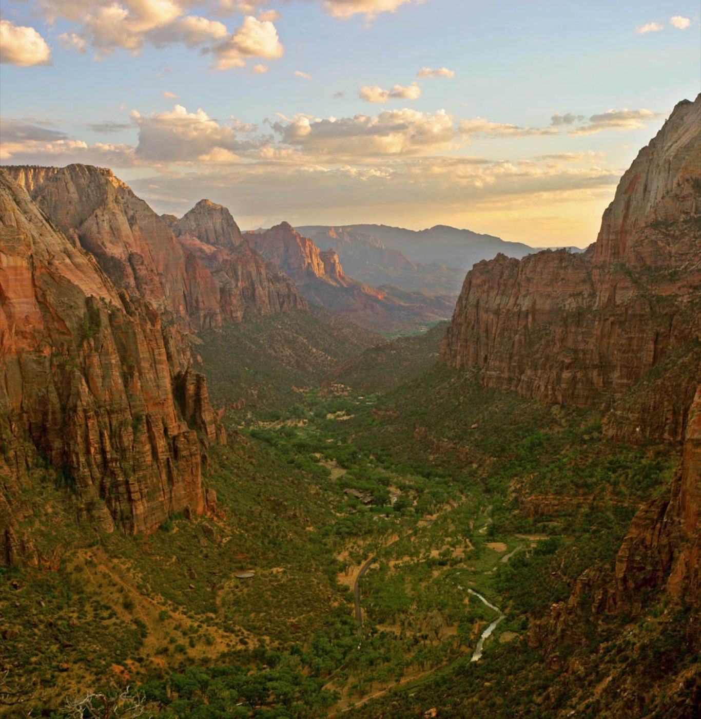
Zion is Utah's most visited national park and the reason is obvious the moment you drive into the canyon — 2,000-foot Navajo sandstone walls close in around the Virgin River in cream, salmon, and rust stripes, and the river keeps cutting. It's a canyon you experience from the inside looking up, more than from overlooks looking down, which gives the whole park a different feel than the rim-based parks elsewhere on the Colorado Plateau. The other thing to know before you go: the main scenic drive through Zion Canyon is closed to private vehicles from March through late November. You park at the visitor center and take the park shuttle, which runs every 7 to 10 minutes up the canyon and stops at every major trailhead. It's well-run and it works — but it also means your day is structured around the shuttle schedule and you need to arrive early. Angels Landing now requires a lottery permit for the final chain-assisted section. The Narrows only opens when the Virgin River is running low enough to wade safely. Zion rewards planning more than most parks, and a midweek visit in spring or fall is a materially different experience than a July weekend.
What to See & Do
The Narrows — wading upstream through a 1,000-foot-deep slot canyon
From the end of the Riverside Walk, you step off the paved path and into the Virgin River itself — and keep walking. The Narrows is a canyon so tight that the river fills it wall to wall, and you wade upstream through ankle-to-waist-deep water with walls soaring a thousand feet overhead on both sides. Rent canyoneering shoes, neoprene socks, and a walking stick from Zion Outfitter outside the park entrance. Go as far as Big Spring (five miles up, ten round trip) or turn around whenever you've had enough. The river runs warmest June through September and is closed during high flow from spring runoff.
Angels Landing chain-assisted ridge walk (permit required)
Angels Landing is a knife-edge sandstone fin rising 1,500 feet above the canyon floor, and the last half-mile to its summit follows a chain bolted into the rock along a ridge with sheer drops on both sides. The full hike is five miles round trip with steep Walter's Wiggles switchbacks to reach Scout Lookout, where the chains begin. A permit is now required year-round to go past Scout Lookout — enter the seasonal lottery on recreation.gov well in advance. Don't attempt the chains in rain, snow, or high wind; people have died on this route.
Observation Point trail for the park's most expansive view
From 2,100 feet above Angels Landing, Observation Point looks back down across the entire canyon with Angels Landing itself below you. The main trail from Weeping Rock has been closed by rockfall since 2019, but you can reach the overlook from the east side via the East Mesa Trail off the East Zion plateau — 7 miles round trip, much flatter, no exposure. A shuttle or second car is required since the trailhead is well outside the Zion Canyon scenic drive. It's the best big-view hike in the park without Angels Landing's exposure or permit.
Emerald Pools cascading waterfalls trail system
The Emerald Pools trails are the easy-to-moderate family hike of Zion — a series of three pools fed by seeping springs that drip off the canyon walls in thin waterfalls. The Lower Pool is a paved 1.2-mile round trip; continuing to the Middle and Upper Pools adds distance and moderate climbing for a three-mile total. Go early or in the last two hours of light — the trails sit in afternoon shade from the west canyon wall, and the dripping springs are more dramatic when low-angle sun hits the hanging gardens. Swimming is prohibited.
Canyon Overlook Trail — a short hike to a stunning viewpoint
Just past the east end of the Zion-Mount Carmel Tunnel, this half-mile trail is the park's highest-payoff short hike — rolling sandstone steps along a ledge that ends at a guardrailed overlook staring straight down into Pine Creek Canyon and across to the Towers of the Virgin. One mile round trip, about an hour with photo stops. It's outside the shuttle system so you drive directly to the trailhead off the highway. Parking is tight — go at sunrise or expect to circle.
Zion-Mount Carmel Highway and its mile-long tunnel
The engineered drive from the canyon floor up to the park's east entrance is a destination in itself. Six switchbacks climb the west wall, then the road ducks into the 1.1-mile Mount Carmel Tunnel — a 1930s CCC-era marvel with gallery windows cut through the sandstone to the canyon below. On the east side, the landscape changes completely: slickrock domes, bighorn sheep grazing along the shoulder, and Checkerboard Mesa's cross-hatched sandstone patterns. Oversize vehicles (RVs, trailers) need a tunnel permit and escort, so check ahead.
Kolob Canyons scenic drive in the park's quieter northwest corner
The Kolob Canyons district is a separate entrance 40 miles northwest of the main canyon off I-15, with its own visitor center and a 5-mile scenic drive up to Timber Creek Overlook. You'll encounter a fraction of the crowd for finger canyons in the same red Navajo sandstone. The Timber Creek Overlook Trail is an easy 1-mile round trip with big views; Taylor Creek Trail is a 5-mile round trip that ends at the Double Arch Alcove. It's the right half-day if the main canyon is feeling overwhelmed.
Getting There & When to Go
Most visitors fly into Las Vegas, a 2.5-hour drive southwest. Salt Lake City is four and a half hours north. March through May and September through November are the prime hiking months — daytime highs in the 70s and 80s, Virgin River low enough for The Narrows, crowds lighter than summer but not thin. Summer is hot (triple digits in July) and crowded; winter is quiet with occasional snow on the high trails and reduced shuttle service. From March through late November, private vehicles are not allowed in Zion Canyon — you take the park shuttle from the visitor center. Arrive before 8 a.m. in peak season or expect to park in Springdale and ride the town shuttle to the entrance.
Where to Stay
The only lodging inside the park is Zion Lodge, centered on the canyon floor — booking six to twelve months ahead is standard for peak season. Outside the park, Springdale is the immediate gateway and walking distance from the main entrance, packed with hotels, cabins, and vacation rentals across every price tier; the town shuttle connects hotels to the park entrance so you don't need to move your car all day. For quieter, cheaper options, Hurricane and La Verkin sit 20 minutes west and offer more chains and larger properties. If you're doing the Kolob Canyons section, Cedar City 40 minutes north is the better base.
Frequently Asked Questions
- Do I need to take the shuttle in Zion Canyon?
- Yes, from March through late November. The Zion Canyon Scenic Drive is closed to private vehicles during those months — you park at the visitor center (or in Springdale) and ride the free park shuttle, which runs every 7 to 10 minutes. Outside that window, you can drive the scenic drive yourself.
- How do I get a permit for Angels Landing?
- Apply through the seasonal lottery on recreation.gov. Lotteries run a few months in advance for each season, plus a day-before lottery for a small number of next-day permits. You need a permit only for the final chain section past Scout Lookout; the hike to Scout Lookout itself is open to everyone.
- When is it safe to hike The Narrows?
- When the Virgin River flow is below 150 cubic feet per second — the NPS posts current flow and closure status daily. Spring runoff typically closes The Narrows from mid-April through late May. Summer flash-flood risk from thunderstorms can also close it on short notice. Check the ranger report the morning of your hike.
- Is Zion doable with young kids or limited mobility?
- Yes — the Pa'rus Trail is a paved, stroller-friendly path along the Virgin River, and the Riverside Walk at the end of the shuttle route is paved for about a mile. Emerald Pools' lower loop is paved. Shuttles are wheelchair accessible. Skip Angels Landing and the upstream Narrows, but the canyon floor itself is manageable for most ability levels.
Plan Your Visit
Book Nearby HotelsZion Planning Guides
Compare focused Zion National Park lodging, itinerary, and activity guides before you book.
Things to do
Things to Do in Zion National Park
Explore the best things to do in Zion National Park, including The Narrows, Angels Landing, Emerald Pools, Canyon Overlook, and Springdale planning tips.
Where to stay
Where to Stay Near Zion National Park
Compare where to stay near Zion National Park, including Springdale, Zion Lodge, Hurricane, La Verkin, and Cedar City.
Itinerary
Zion National Park Itinerary
Plan a Zion National Park itinerary for one, two, or three days with The Narrows, Angels Landing, Emerald Pools, Canyon Overlook, and Springdale.
Have you visited Zion?
Track all 63 national parks on your map