National Park · UT · Est. 1928
Bryce Canyon
Overview
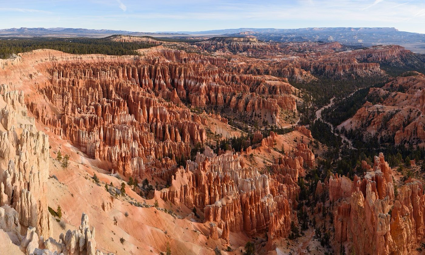
Bryce Canyon isn't actually a canyon — it's a series of natural amphitheaters cut into the edge of the Paunsaugunt Plateau, where frost and rainwater have carved the pink cliff rock into forests of stone spires called hoodoos. The scale is smaller than its Utah neighbors (you can see most of the main amphitheater from a handful of overlooks) but the effect, especially at sunrise, is unlike anywhere else. The hoodoos glow orange-red against the blue shadows of the bowl below. Because the park sits at 8,000 to 9,000 feet, it stays cooler than Zion or the Grand Canyon — a genuine relief in July. It also means winter transforms the place: snow on orange hoodoos, freezing nights, and almost no one around. The main visitor experience is the 18-mile scenic drive along the rim with 13 marked overlooks, plus a handful of superb short hikes that drop you down into the amphitheater for an hour or two. Bryce also has some of the darkest night skies in the country — a Bortle Class 2 rating that makes the Milky Way look nearly three-dimensional.
What to See & Do
Navajo Loop and Queen's Garden combination trail through the hoodoos
The Navajo Loop plus Queen's Garden combo is the park's signature hike and for good reason — 3 miles, 600 feet of elevation change, and the best up-close-to-the-hoodoos experience you'll get in one loop. Start at Sunset Point, descend the switchbacks of Wall Street (closed in winter due to rockfall), walk through the hoodoo amphitheater floor past the Queen Victoria formation, and climb back out to Sunrise Point. Budget 2 to 3 hours. The uphill return is the hard part — at 8,000 feet, pace yourself.
Inspiration Point at sunrise when the amphitheater glows
Sunrise here is the moment every photographer chases. Arrive 30 minutes before sunrise at Inspiration Point — the three-tier overlook on the main amphitheater rim — and watch the hoodoos light up row by row as the sun clears the horizon. The middle tier is the best balance of height and crowd, and the walk from the parking pullout is only a few hundred yards. In winter, the plowed path may be icy; microspikes are cheap and make the difference.
Bryce Amphitheater from Sunset Point
Sunset Point, despite the name, is excellent any time of day — it's the classic front-row seat on the main amphitheater where the hoodoo density is highest. Thor's Hammer is visible from here and from the short spur trail along the rim. Sunrise and golden hour are best for photography; midday is fine for families who want to stroll the paved rim trail between Sunrise and Sunset Points, a flat 0.5-mile walk with uninterrupted views the entire way.
Astronomy ranger programs under Bortle Class 2 skies
Bryce is one of the darkest national parks in the Lower 48, with a Bortle rating of 2 over the main amphitheater. Summer astronomy programs meet at the visitor center several nights a week, with telescopes for Saturn, Jupiter, and deep-sky objects, plus constellation talks. The annual Astronomy Festival in June brings guest astronomers and dozens of telescopes. Even without a program, walking to Sunset Point after dark and looking up is the main event — bring a red flashlight to preserve night vision.
Peek-A-Boo Loop Trail through tunnels and arches
The Peek-A-Boo Loop is a 5.5-mile horseshoe-shaped trail that drops from the rim into the amphitheater and weaves through narrow hoodoo tunnels, under arches, and around fin formations. It's more demanding than the Navajo-Queen's Garden combo — 1,500 feet of elevation change — but it's also where most of the crowds thin out. Start at Bryce Point, go clockwise, and plan on 4 to 5 hours. Trail runners use this loop as their long run; horse groups use it too, so watch your footing on the soft sections.
Fairyland Loop's 8-mile rim-to-floor circuit
Fairyland Loop is an 8-mile trail at the quiet north end of the park with a full trip down into the amphitheater, across the floor, and back up — 1,700 feet of cumulative climb. Tower Bridge and the China Wall are highlights along the way. The trailhead is at Fairyland Point, which is outside the paid entrance station, so you can do the loop even on a transit-shuttle day. Budget 5 to 6 hours, bring 3 liters of water in summer, and start early to avoid the heat and afternoon thunderstorms.
Thor's Hammer hoodoo — the park's most iconic formation
Thor's Hammer is the single most photographed hoodoo in Bryce — a boulder balanced on a narrow spire of white limestone in the main amphitheater. You can see it from Sunset Point on the rim, but the best perspective is from the Navajo Loop trail as you descend into the bowl. Early morning light makes the hammer head glow. It won't stand forever — frost wedging is actively eating at the neck, and eventually it'll fall like its predecessors. See it while it's there.
Getting There & When to Go
Las Vegas is the nearest large airport at about 4 hours southwest; Salt Lake City is 4 hours north. Bryce sits on Utah 12, one of the most scenic drives in the state, so many visitors combine it with Zion (90 minutes southwest) and Capitol Reef (2 hours northeast) on a loop. May through October offers the full-access season with the park shuttle running from April through mid-October. July and August see afternoon thunderstorms and the biggest crowds. September into early October is the sweet spot — warm days, cool nights, aspens turning. Winter is quiet and spectacular but cold at elevation; the main overlooks stay plowed and accessible.
Where to Stay
The Lodge at Bryce Canyon, built in 1925 and part of the original Union Pacific tourism push, is the only in-park lodging and books out 9 to 12 months ahead — its historic cabins have working stone fireplaces. Just outside the entrance, Ruby's Inn is a sprawling Western-themed complex with its own general store, gas station, and restaurants, and it's what most visitors actually stay at. For more charm, drive 30 minutes west to Panguitch, a small Mormon pioneer town with historic brick homes and a handful of independent hotels and inns at better prices than the park gateway.
Frequently Asked Questions
- How does Bryce Canyon compare to Zion?
- They're complementary, not competing. Zion is a narrow canyon you hike up into with sheer sandstone walls, while Bryce is an amphitheater you look down into and descend. Bryce sits 3,000 feet higher, so summer is cooler and winter can be snowy. Most visitors do both — they're 90 minutes apart on UT-12 and UT-9.
- Do I need the park shuttle or can I drive my car?
- You can drive your car the entire 18-mile scenic drive year-round. The free shuttle runs April through mid-October from the visitor center to the main amphitheater overlooks and is convenient during peak summer parking crunches but not required. Outside peak season, driving yourself is usually easier.
- Can I hike into the amphitheater without backcountry experience?
- Yes. The Navajo Loop, Queen's Garden, and combined Navajo-Queen's Garden trails are all signed, paved or well-graded, and appropriate for day hikers in reasonable shape. The main caution is elevation — the rim is 8,000 to 9,000 feet, so the return climb feels harder than the numbers suggest. Pace yourself and carry water.
- Is Bryce open in winter?
- Yes, year-round. Most of the scenic drive and the main amphitheater overlooks stay plowed, though some trails (Wall Street switchbacks, Peek-A-Boo Loop) close seasonally due to ice. Cross-country skiing and snowshoeing on the rim are popular. The Lodge closes November through March; Ruby's Inn outside the entrance stays open all year.
Plan Your Visit
Book Nearby HotelsHave you visited Bryce Canyon?
Track all 63 national parks on your map