National Park · UT · Est. 1971
Capitol Reef
Overview
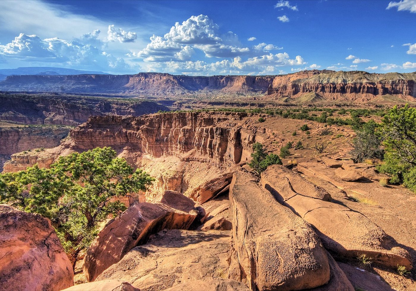
Capitol Reef is the Utah park that most people drive past on their way between Bryce and Canyonlands — and then realize later they should have stopped for three days. The central feature is the Waterpocket Fold, a 100-mile buckle in the Earth's crust where sedimentary rock layers got bent into a tilted monocline during the uplift that built the Colorado Plateau. The result is a landscape of colorful domes, hidden slot canyons, and natural bridges that feels bigger and wilder than the park's small visitor footprint suggests. The paved scenic drive runs just 8 miles into the fold from Highway 24, but it delivers one of the best ratios of scenery to effort in the Utah parks. Beyond it, dirt roads push north into Cathedral Valley and south along the Notom-Bullfrog road for days of backcountry driving. The Fremont River runs through the middle of the park, supporting the historic Mormon pioneer orchards at Fruita — still actively farmed, with U-pick apples, apricots, and peaches in season. And because Capitol Reef sits away from Utah's big-name parks, the stargazing here is a Gold Tier International Dark Sky designation.
What to See & Do
Hickman Bridge Trail to a 133-foot natural bridge
Hickman Bridge is the park's signature short hike — a 1.8-mile round-trip trail to a 133-foot-wide natural bridge spanning a dry wash. The path climbs a sandstone bench with views across the Fremont River valley, passes a small Fremont Indian granary, and delivers you underneath the bridge with enough room to stand in its shadow. Budget 90 minutes. Morning light is best for photography; the bridge opening faces south-southeast. In summer, start early — the exposed sections get hot by 10 a.m.
Capitol Gorge petroglyph panels and pioneer register
At the end of Scenic Drive, the dirt Capitol Gorge spur road runs a mile into a narrow canyon that served as the main wagon route through this section of the fold until 1962. Walk the 2-mile round-trip trail past Fremont petroglyph panels on the canyon walls and the Pioneer Register, where Mormon settlers carved their names into the sandstone in the 1880s. Flash flood risk is real here — check the forecast before you go, and turn around if thunder is audible. The walk is sandy but flat.
Panorama Point stargazing under Gold Tier dark skies
Capitol Reef earned Gold Tier Dark Sky status from the International Dark Sky Association — the highest rating. Panorama Point, 3 miles west of the visitor center off Highway 24, is the best accessible stargazing spot, with 270-degree open sky and almost no light pollution. On a moonless summer night, the Milky Way is bright enough to cast faint shadows. The park hosts astronomy programs at the Fruita Campground amphitheater multiple nights a week in summer.
Gifford Homestead for fresh-baked fruit pies from orchard fruit
The Gifford Homestead in the Fruita historic district is a working reconstruction of an early 20th-century Mormon farmhouse — and more relevant, a bakery selling fresh-baked mini fruit pies from the park's own orchards. Apricot, apple, cherry, and mixed-berry pies typically sell out by early afternoon in summer, so go in the morning. The orchards surrounding the homestead are still actively managed; in season (June through October) you can pick your own for a small fee. Pair the pie with a picnic along the Fremont River.
Scenic Drive along the Waterpocket Fold monocline
Scenic Drive is the paved 8-mile road from the visitor center south along the Waterpocket Fold. It's the best single orientation to what the park is — sandstone domes and cliffs on both sides, colored everything from deep red to cream white. Allow 2 hours for the round trip with stops at the pullouts. The Grand Wash and Capitol Gorge dirt spurs branch off partway and add another 1 to 3 hours if you want to drive into the narrow canyons themselves.
Cassidy Arch overlook and the outlaw history
Cassidy Arch is named after Butch Cassidy, who according to local legend used the remote canyons of Capitol Reef as a hideout in the 1890s. The trail is 3.4 miles round-trip from Grand Wash trailhead, climbs 670 feet, and puts you on top of the arch rather than under it — a different experience than Arches National Park, and one that lets you walk right across the sandstone span. The drop on both sides is serious; don't attempt this with small kids or in high wind.
Cathedral Valley's monolithic sandstone Temples of the Sun and Moon
Cathedral Valley in the park's north end is the less-visited half of Capitol Reef, reached by a 58-mile dirt-road loop that requires high clearance, a river ford across the Fremont, and a full day. The payoff is standing at the base of the Temple of the Sun — a 400-foot freestanding monolith of Entrada sandstone rising out of empty desert — and the slightly shorter Temple of the Moon next to it. Check road conditions at the visitor center before you go; the clay sections turn to impassable gumbo after rain.
Getting There & When to Go
Capitol Reef is the least accessible of Utah's five national parks — there's no major airport nearby. Salt Lake City is about 3.5 hours northwest; Grand Junction, Colorado, is under 3 hours east; Las Vegas is about 5 hours southwest. Most visitors reach it as part of a multi-park loop on the spectacular Utah 12 and Highway 24. March through May and September through November are the peak windows — mild temperatures, golden cottonwoods along the river in fall, and fewer crowds than at Zion or Bryce. Summer is hot but the park is much quieter than its neighbors. Winter sees occasional snow but the main roads stay open.
Where to Stay
The park itself has only the Fruita Campground — 71 sites on the Fremont River among the orchards, reservable March through October and highly prized. Outside the park, Torrey (11 miles west of the visitor center) is a small town with a surprising range of lodging: the Capitol Reef Resort with log-cabin style rooms, the Broken Spur Inn, and a handful of vacation rentals and independent motels. For a splurge, the Lodge at Red River Ranch outside Teasdale offers a high-end Western ranch experience with farm-to-table dining. Bicknell and Loa, 20 to 30 minutes further west, have budget motel options.
Frequently Asked Questions
- How much time do I need at Capitol Reef?
- A half-day hits the visitor center, the scenic drive, and the Hickman Bridge trail — enough for a taste. Two full days lets you add Grand Wash or Cassidy Arch and enjoy the Fruita orchards and historic district. Three or more days opens up Cathedral Valley and the Notom-Bullfrog road for true backcountry driving.
- Can I really pick fruit in the orchards?
- Yes, seasonally. The NPS actively maintains the historic Mormon pioneer orchards and announces picking windows each season — typically June for cherries and apricots, July for peaches and pears, August through October for apples. During designated picking periods you pay a modest per-pound fee on the honor system. Check the park website before your trip for current fruit status.
- Is the Scenic Drive suitable for all cars?
- Yes, the paved 8-mile Scenic Drive is fine for any passenger vehicle including low-clearance cars and motorcycles. The unpaved Grand Wash and Capitol Gorge spurs are passable by most cars in dry weather but can flood during storms. Cathedral Valley and Notom-Bullfrog roads require high clearance and should not be attempted in rain.
- Are there reliable services inside the park?
- Limited. The visitor center has potable water, restrooms, and ranger information. There's no fuel, no food service (aside from Gifford Homestead's seasonal pies), and no lodging inside the park. Plan to fuel up and grocery-shop in Torrey before entering, especially if you're doing any backcountry driving.
Plan Your Visit
Book Nearby HotelsHave you visited Capitol Reef?
Track all 63 national parks on your map