National Park · UT · Est. 1964
Canyonlands
Overview
Canyonlands is the Utah park that most first-time visitors underestimate. It's the state's largest national park — 337,000 acres of canyons, mesas, and river gorges carved by the Colorado and Green Rivers into a wilderness that still reads as genuinely remote. Unlike Arches or Zion, you won't see all the highlights from a paved overlook loop. Canyonlands is four separate districts that don't connect by road, and the one you pick shapes your entire trip. Island in the Sky is where most visitors go — a flat-topped mesa 2,000 feet above the canyon country, accessible by paved road from Moab and home to the iconic Mesa Arch sunrise shot. The Needles, to the south, is a jumble of banded sandstone spires reached by a separate entrance and rewards day-hikers with some of the best mid-distance trails in the state. The Maze, west of the Colorado, is the least visited area in any national park — genuinely expedition territory, requiring a high-clearance 4x4 and days of preparation. Plus the rivers themselves, which cut through the heart of the park and offer everything from flatwater paddling to Class V whitewater in Cataract Canyon.
What to See & Do
Mesa Arch at sunrise — the iconic glowing arch photograph
Mesa Arch is the shot you've seen a hundred times — a small sandstone arch perched on a cliff edge, its underside lit up by the rising sun like a filament. The trail from the pullout is a quarter-mile and easy, but the arch is small and the photo spots are limited. In shoulder season you'll have tripods three deep 45 minutes before sunrise; in summer, expect a crowd. The glow lasts maybe 10 minutes after first light. Skip sunrise if you want the arch to yourself — midday is quiet.
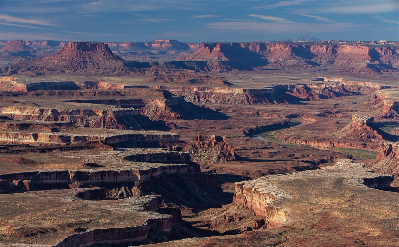
Grand View Point overlooking the canyon labyrinth
Grand View Point is the end-of-the-road overlook at Island in the Sky, and it's the view that explains what Canyonlands actually is. From the railing, you're staring down 2,000 feet into a maze of red rock canyons that stretch 100 miles to the horizon. The short spur trail along the rim adds better angles — walk it to the end for more intimate overlooks with fewer people. Sunset is the prime time here, when the canyon walls light up and the shadows stretch across the lower terrace.
White Rim Road 4x4 or mountain bike adventure (100 miles)
The White Rim Road is a 100-mile dirt loop that circles below the Island in the Sky mesa on a bench of white sandstone 1,000 feet down from the rim. It's a multi-day trip — most people take 3 to 4 days in a 4x4 with a support vehicle, or bike it self-supported with a rafting-style shuttle. Overnight permits book out months in advance; the NPS limits the number of vehicles to keep the experience remote. The campsites along the route sit on blank rock shelves with nothing between you and the canyon walls.
The Needles District's Chesler Park loop through sandstone spires
Chesler Park is a mid-distance loop — 11 miles with the optional Joint Trail spur — through banded red-and-white sandstone spires that define the Needles district. The Joint Trail portion squeezes through cracks between the fins, some only a few feet wide with 80-foot walls overhead. Budget 6 to 8 hours for the full loop; start early in summer and carry 3 liters of water. The Needles entrance is 90 minutes south of Moab on a separate road — there's no direct connection to Island in the Sky from inside the park.
Cataract Canyon whitewater rafting (Class III–V)
Where the Colorado and Green Rivers meet inside the park, the water picks up speed and drops 30 feet per mile through Cataract Canyon — the biggest commercial whitewater in Utah. Outfitters in Moab run 2- to 5-day trips, with the big rapids concentrated in a single day. May and June bring the highest water and the most aggressive Class V; July onward, the rapids mellow to big-volume Class III–IV. You can also run the upper sections as flatwater on a self-guided canoe trip if whitewater isn't your thing.
Upheaval Dome's mysterious crater origin
Upheaval Dome is a 3-mile-wide crater on the west side of Island in the Sky that geologists spent 50 years arguing about — is it a collapsed salt dome or a meteor impact? Current consensus leans toward impact, and the evidence is shocked quartz found at the site. A short 1-mile round-trip trail reaches the first overlook; a 4.5-mile round trip takes you to the deeper second overlook on the crater rim. Go in the morning before the sun flattens out the colors inside the crater.
The Maze — one of the most remote places in the continental U.S.
The Maze district on the west side of the Colorado is functionally expedition country. Reaching the trailheads requires a high-clearance 4x4 on technical dirt roads, and a wrong turn can leave you 50 miles from help with no cell service. NPS recommends you be fully self-sufficient with extra fuel, water, and a PLB or satellite communicator. Once there, trails like the Maze Overlook into the Land of Standing Rocks are among the wildest hikes in the Lower 48. This is not a casual day-trip destination — start with a guided outfitter if you're new to the area.
Horseshoe Canyon and the Great Gallery rock-art panel
Horseshoe Canyon is a detached unit of Canyonlands, separated from the rest of the park and reached on its own — about 30 miles of graded dirt road off UT-24 between Hanksville and Green River. The reason to make the drive is the Great Gallery: a 200-foot-long panel of Barrier Canyon Style pictographs painted between 2,000 and 4,000 years ago, with life-sized human figures in red ochre that are widely considered the finest prehistoric rock art in North America. The hike is 7 miles round-trip and 750 feet down into the canyon and back out. Carry plenty of water, start early, and take a ranger-led walk on weekends in spring and fall if you can — the interpretation is what makes the panels make sense. The dirt access road is impassable when wet.
Getting There & When to Go
Salt Lake City is about 4 hours north; Grand Junction, Colorado, is 2 hours east. Most visitors fly into one or the other and drive to Moab, which is 30 minutes from the Island in the Sky entrance and 90 minutes from the Needles. March through May and September through November are ideal — daytime highs in the 60s and 70s, cool nights, and manageable crowds. Summer (June through August) is brutal, with canyon temperatures regularly exceeding 100°F and no shade on most trails. Winter is quiet and striking when snow dusts the red rock, but some dirt roads close and hiking at elevation gets cold.
Where to Stay
Moab is the obvious base for Island in the Sky — a full tourist town with hotels, vacation rentals, restaurants, and outfitters, plus easy access to Arches just next door. Book ahead in spring and fall shoulder seasons; Moab fills up. For the Needles District, Monticello is the closer small-town base (45 minutes north of the entrance), with limited but functional motel options. There's no lodging inside any of the districts — only campgrounds, which require reservations at Island in the Sky's Willow Flat and first-come at the Needles' Squaw Flat. Backcountry permits are free but regulated.
Frequently Asked Questions
- Which Canyonlands district should I visit first?
- Island in the Sky if you have one day and want paved roads with iconic overlooks — Mesa Arch, Grand View Point, and Upheaval Dome are all here. Needles if you have two or more days and want to hike hard through sandstone spires. The Maze only if you have a week, a 4x4, and real backcountry experience.
- Can I visit Canyonlands and Arches in one trip?
- Yes — they're 30 minutes apart and most Moab visitors do both. A common itinerary is two days at Arches and two days at Island in the Sky, with a side trip down to the Needles if you have a fifth day. The two parks complement each other: Arches is compact and accessible, Canyonlands is vast and remote.
- Do I need a 4x4 to enjoy the park?
- No, not for Island in the Sky or the Needles main areas — both are reached by paved roads with paved spur drives to most overlooks. A 4x4 is required for the White Rim Road, Elephant Hill in the Needles, and virtually everywhere in the Maze. Rentals are available in Moab but book ahead.
- Is there water available in the park?
- Limited. The Island in the Sky visitor center has potable water seasonally; the Needles visitor center has it year-round. No trails have water sources, and summer temperatures make dehydration a real hazard. Carry and plan on 4 liters per person per day in warm months, less in winter. Don't count on finding water in the backcountry.
Plan Your Visit
Book Nearby HotelsHave you visited Canyonlands?
Track all 63 national parks on your map