National Park · CO · Est. 1999
Black Canyon of the Gunnison
Overview
Black Canyon of the Gunnison is the park that makes you back away from the railing. The Gunnison River has spent two million years cutting through some of the oldest exposed rock in North America — Precambrian gneiss and schist nearly two billion years old — and the result is a gorge so narrow and so deep that sunlight only reaches the bottom for a few minutes a day. The walls are that dark, and the drop is genuinely vertical. Most of the park experience happens along the 12 overlooks of South Rim Drive, where you can stop, walk 50 to 200 yards, and stare straight down 1,800 to 2,700 feet. The North Rim is quieter and a three-hour drive around from the visitor center; big-wall climbers and canyon scramblers make the pilgrimage there for the Painted Wall routes. You'll hear the river roaring at the bottom on calm days, but you won't see much of it from above — that's part of the disorientation. Come for the geology, the vertigo, and an unusually quiet corner of Colorado that sees a fraction of Rocky Mountain's crowds.
What to See & Do
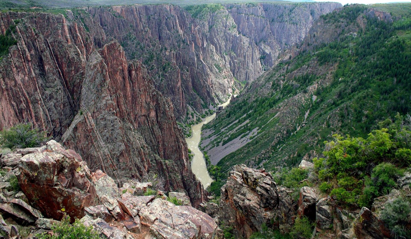
Painted Wall — Colorado's tallest cliff face at 2,250 feet
The Painted Wall drops 2,250 feet — taller than two Empire State Buildings stacked — and the wild pink veins crossing it are 1.4-billion-year-old pegmatite that squeezed up through the dark gneiss while it was still deep underground. Pull off at Painted Wall View on the South Rim Drive and walk the short spur trail to the railing. It's best photographed in late afternoon when the sun rakes across the face and the pegmatite veins light up. Bring a telephoto if you want to watch climbers the size of ants on the multi-day routes below.
Chasm View overlook for the canyon's narrowest point
From Chasm View on the South Rim, the canyon pinches to 1,100 feet across at the top and just 40 feet at the river below — a ratio so severe it looks edited. You can hear the river clearly from here when the wind is quiet. The overlook is reached by a short paved walk from the parking pullout; a second spur to Painted Wall is a quarter-mile further. Go in the morning, when the east-facing wall catches first light and the shadows still fill the cut.
South Rim Road's 12 dramatic viewpoints
The 7-mile South Rim Drive runs from the visitor center to High Point, with 12 marked overlooks along the way — most requiring a short walk of a few hundred yards from the pullout. Plan on a half to a full day to do them all, stopping longer at Gunnison Point, Chasm View, Painted Wall, and Sunset View. The road closes from late November through early April; if you're here in shoulder season, check conditions before you commit the drive.
Gunnison Route descent to the river bottom (Class IV scramble)
The Gunnison Route is the park's most famous non-technical way down to the river — non-technical meaning you don't need ropes, but you do need an 80-foot chain bolted into the rock to help you down one pitch. It's 1,800 vertical feet in a mile, loose underfoot, and unforgiving. Pick up the free wilderness permit at the visitor center, start early, carry three liters of water, and budget at least five hours round-trip. The reward is standing in the narrow bottom with the walls closing overhead and the river rumbling past.
Warner Point Nature Trail to the canyon's deepest view
At the far western end of South Rim Drive, Warner Point is a 1.5-mile round-trip nature trail ending at the overlook for the canyon's deepest point — 2,722 feet from rim to river. The trail winds through Gambel oak and pinyon-juniper with interpretive signs on the local ecology. It's the least-trafficked of the South Rim's major viewpoints because most drivers turn around before High Point. Go at sunset, when the La Sal Mountains of Utah are visible 80 miles west and the canyon rim turns orange.
Kayaking and fly-fishing the Gunnison River below
The river through the inner canyon is a Gold Medal trout fishery — rainbows and browns in the 14- to 22-inch range are routine — but reaching it requires commitment. The East Portal Road down to the river inside the park is paved but brutally steep (16% grade) and towing is prohibited. Once you're down, the river below Crystal Dam offers walk-and-wade fly-fishing in exceptionally clear water. The rapids deeper in the canyon are Class V and reserved for expert kayakers with a permit.
Stargazing from the South Rim campground
Black Canyon is designated an International Dark Sky Park, and the South Rim Campground at 8,300 feet puts you above most of the atmospheric haze. On a moonless summer night you can see the Milky Way reflecting in the sagebrush flats between the rim and the campground. Rangers host astronomy programs at the amphitheater on summer weekends with telescopes set up for Saturn, Jupiter, and whatever's in season. Dress warm — even July nights at this elevation drop into the 40s.
Getting There & When to Go
Montrose Regional Airport is 20 minutes from the South Rim entrance and is the closest option, though connections are limited; Grand Junction is 90 minutes away with more flights, and Denver is a 5-hour drive over the mountains. May through October is the practical season — the South Rim road is plowed and all overlooks are open. June through August brings the warmest weather and peak crowds (which are still modest compared to Colorado's other parks). September and October are the best combination of open access, thin crowds, and golden aspens on the approach drives. The North Rim closes entirely in winter; the South Rim road closes from late November through early April.
Where to Stay
There's no in-park lodge — only the South Rim Campground and the more primitive North Rim Campground. Most visitors base themselves in Montrose, a working Colorado town 15 miles from the entrance with a range of budget and mid-range hotels and an easy breakfast commute to the rim. For more character, Ouray (an hour south) is a classic Victorian mining town with hot springs and the San Juan Mountains at the doorstep — it works well for a two-park trip that pairs Black Canyon with a drive over Red Mountain Pass. Gunnison, an hour east, is the gateway for the North Rim and Curecanti National Recreation Area.
Frequently Asked Questions
- How long do I need to see Black Canyon of the Gunnison?
- A focused day is enough for the South Rim's 12 overlooks if you're selective. Two days lets you do the full rim drive at a relaxed pace plus either the Warner Point or Oak Flat short trails. Add a third day if you want to attempt the Gunnison Route descent to the river, which is strenuous enough to eat an entire day on its own.
- Can I drive from the South Rim to the North Rim?
- Not directly — there's no bridge or road across the canyon inside the park. The drive around is roughly 2 to 3 hours via US-50 and CO-92. Most visitors pick one rim and commit, with the South Rim offering more overlooks and the North Rim offering more solitude and dramatic climbing walls.
- Is the canyon safe for kids?
- Yes, as long as adults supervise at overlooks — most railings are close to the edge and a few viewpoints have drop-offs without barriers. Keep small children within arm's reach near rims and leashes on pets. The South Rim's short interpretive trails are appropriate for families; the Gunnison Route and inner-canyon descents absolutely are not.
- Is cell service available in the park?
- Barely. Verizon and AT&T work intermittently at the South Rim visitor center and campground, and almost nowhere else in the park. Download maps offline and don't rely on rideshare or remote work plans. The nearest reliable signal is back in Montrose.
Plan Your Visit
Book Nearby HotelsHave you visited Black Canyon of the Gunnison?
Track all 63 national parks on your map