National Park · NV · Est. 1986
Great Basin
Overview
Great Basin sits alone in east-central Nevada, hours from any city, protecting a high desert mountain island that rises from sagebrush flats to a 13,063-foot glacier-capped summit. It's Nevada's only national park and one of the least-visited in the lower 48, which is a feature, not a bug — you can walk most of its trails without passing anyone. What makes this park unusual is how much is packed into a small footprint. In a single day you can tour a marble cave system decorated with shields and stalactites, walk among bristlecone pines older than the pyramids, climb through three life zones to an alpine summit, and then stand under some of the darkest skies left in the continental United States. The park is a Gold Tier Dark Sky Park, and on a moonless September night the Milky Way throws enough light to cast a shadow. Bring layers — temperatures swing 40 degrees between the valley floor and Wheeler Peak's shoulder, and afternoon thunderstorms build fast over the ridge in summer. Gas up in Ely before the drive in; services in Baker are minimal.
What to See & Do
Lehman Caves ranger-guided tour through marble chambers
The only way to see the cave is on a ranger-led tour, and they sell out — book on recreation.gov weeks ahead in summer. The 90-minute Grand Palace tour walks you through the decorated chambers past rare shield formations found in only a handful of caves worldwide. It stays a constant 50 degrees underground, so bring a jacket even when the parking lot is baking. The 60-minute Lodge Room tour is a shorter option if the longer one is booked. Meet at the visitor center 15 minutes early for ticket pickup.
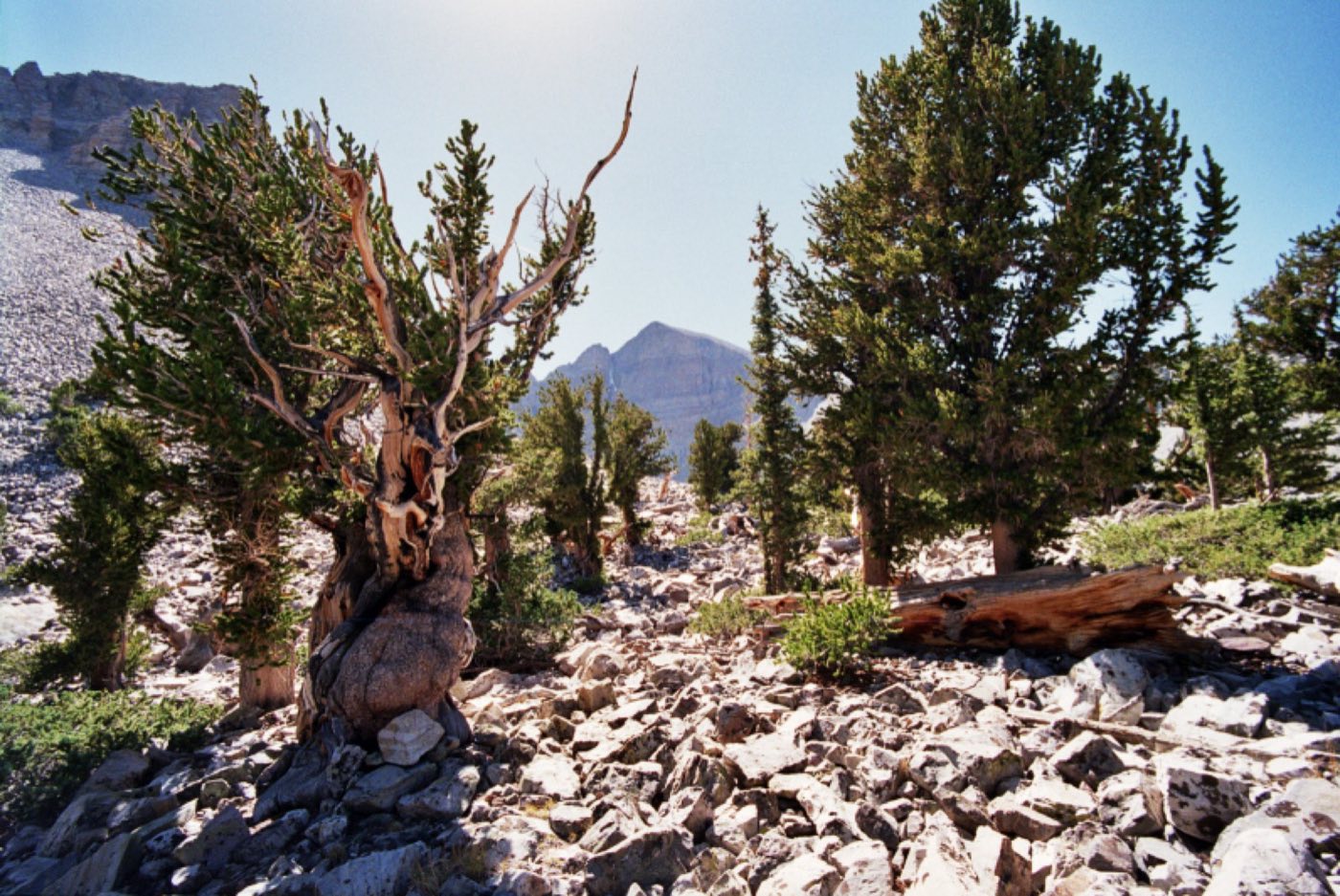
Bristlecone Pine Grove trail among 3,000+ year-old trees
The 2.8-mile roundtrip trail starts at the Wheeler Peak Campground at 9,800 feet and climbs through limber pine into a grove of bristlecones that were already ancient when Rome fell. The trees grow in harsh mineral soil that kills off competitors, and their wood is so dense it barely decays — some of the dead snags you pass have been standing for thousands of years. Take your time with the altitude; the trailhead is already higher than most people live. An interpretive guide at the start explains what you're looking at.
Wheeler Peak summit hike
The 8.6-mile roundtrip to the 13,063-foot summit gains 3,000 feet along an exposed ridge and is one of the most rewarding day hikes in the Great Basin. Start before sunrise to be off the summit by noon — afternoon thunderstorms on a bare ridge are genuinely dangerous. The final mile is a boulder scramble that rewards careful footing. From the top you can see across the basin and range country into Utah, five ranges deep. Acclimatize a day at elevation first if you came from sea level.
Astronomy ranger programs under some of the darkest skies in America
The park's astronomy programs run most weekend nights from Memorial Day through late September at the Lehman Caves Visitor Center amphitheater. Rangers set up telescopes and walk you through the summer Milky Way, Saturn's rings, and deep-sky objects most people have never seen with their own eyes. The annual Astronomy Festival in September brings astronomers from around the country for three nights of telescope viewing. Arrive 30 minutes after sunset for the darkness to fully settle in.
Wheeler Peak Glacier
A 4.6-mile roundtrip hike from the Bristlecone trailhead takes you past the bristlecone grove and up to the base of a small rock glacier tucked into the north cirque of Wheeler Peak — the southernmost glacier in the Great Basin and one of the last south of the 40th parallel. You're climbing to 10,800 feet, and the final stretch is a boulder field with cairns rather than a defined trail. Loose rock and snow linger into July; bring traction if you come early season.
Alpine Lakes Loop past Stella and Teresa lakes
The 2.7-mile loop from the Bristlecone trailhead is the easiest way to get into real alpine scenery here. You'll pass Stella and Teresa lakes, both glacially carved and ringed by limber pine, with Wheeler Peak as a constant backdrop. The trail is rolling rather than steep, which makes it achievable for families, though you're still starting above 9,800 feet. Bring a picnic; the benches at Teresa Lake are one of the best lunch spots in the park.
Lexington Arch
In the remote southern end of the park, Lexington Arch is a six-story limestone arch — unusual because most natural arches are sandstone. The 3.4-mile roundtrip hike climbs through pinon-juniper woodland to a dramatic view of the arch spanning a dry wash. The access road is rough gravel and not suitable for low-clearance cars; a high-clearance vehicle or truck is recommended. Very few visitors make it out here, which is part of the reward.
Getting There & When to Go
The nearest airports are Salt Lake City (234 miles) and Las Vegas (285 miles), both roughly a four- to five-hour drive. Most visitors come via U.S. 50 — the self-styled Loneliest Road in America — through Ely, which is the last real town before the park. Gas up in Ely; Baker, at the park entrance, has only a handful of services. The park is open year-round, but the Wheeler Peak Scenic Drive above the campground typically closes from November through May under snow. June through October is the full season for high-country trails; September is the sweet spot — cool days, dark skies, and the annual Astronomy Festival.
Where to Stay
There are no hotels inside the park, and the surrounding area is genuinely remote. Baker has a handful of small lodges — the Border Inn and Stargazer Inn are the reliable options — plus a few cabins and vacation rentals. Ely, 65 miles west on U.S. 50, has proper hotels and is a reasonable base if you're willing to drive in each morning. The park's five campgrounds run from the Lower Lehman Creek loop near the visitor center up to Wheeler Peak Campground at 9,800 feet, which is one of the highest in the National Park System. Campgrounds are first-come-first-served except Upper Lehman, which takes reservations on recreation.gov.
Frequently Asked Questions
- Do I need a reservation to enter Great Basin?
- No — entry is free and no timed-entry reservation is required. Lehman Caves tours, however, require advance reservations on recreation.gov and sell out in summer, often weeks ahead. Book caves tickets the moment you've set your dates.
- How long does it take to see the park?
- Two full days is a realistic minimum. One day covers the Lehman Caves tour and the Wheeler Peak Scenic Drive with a short hike; a second day lets you do the bristlecone grove or a summit push. Add a third night for a proper astronomy experience.
- Is the drive up Wheeler Peak Scenic Drive difficult?
- The paved road climbs from 6,800 feet at the visitor center to 9,800 feet at Wheeler Peak Campground over 12 miles, with tight switchbacks in the upper section. Vehicles longer than 24 feet are prohibited above Upper Lehman Creek because of the turns. Most cars handle it fine in dry weather.
- Can I see bristlecone pines without a long hike?
- The main Bristlecone Pine Grove requires the 2.8-mile roundtrip hike from Wheeler Peak Campground — there's no drive-up option. The hike is moderate in grade but starts at 9,800 feet, so altitude is the main challenge. Take your time and plan on two to three hours.
Plan Your Visit
Book Nearby HotelsHave you visited Great Basin?
Track all 63 national parks on your map