National Park · CA · Est. 1890
Yosemite
Overview
Yosemite is the American landscape that taught Americans what a national park could be. John Muir walked into the Sierra Nevada valley in 1868 and spent the rest of his life arguing for its protection; Ansel Adams spent the rest of his photographing it. Seven miles long, a mile wide, walled in by El Capitan and Half Dome, Yosemite Valley compresses some of the most recognizable rock in the world into a space you can bike across in an afternoon. What surprises first-time visitors is how much park there is beyond the valley. Tioga Road climbs east for 46 miles into Tuolumne Meadows and the high country — granite domes, alpine lakes, and subalpine meadows at 8,600 feet, empty compared to the valley floor below. The Mariposa Grove protects giant sequoias south of the valley. Glacier Point looks back across the whole scene from 3,200 feet above the Merced River. Summer visitation is intense — over four million people a year, most of them crowded into the seven-mile valley — but timing your entry and staying at least two nights gives you the morning and evening hours when the tour buses are gone and the light on the granite is doing what it's famous for.
What to See & Do
Tunnel View — the iconic panorama of El Capitan, Bridalveil Fall, and Half Dome
As you drive from the south entrance through the Wawona Tunnel, the valley suddenly opens in front of you — El Capitan on the left, Bridalveil Fall on the right, Half Dome framed at the end. The viewpoint is a paved pullout immediately after you emerge from the tunnel. Go at sunrise for the warm light on El Cap's east face, or sunset for the pink alpenglow on Half Dome's north face. Afternoon is heavily touristed but the view still works. Park in the lower lot and walk back up if the main pullout is full.
Mist Trail to Vernal and Nevada Falls
The most popular day hike in Yosemite climbs a granite staircase directly alongside Vernal Fall, getting genuinely drenched in spring mist, then continues up to Nevada Fall's brink at 5,900 feet. The round trip to Vernal is 2.4 miles and moderate; pushing on to Nevada makes it 7 miles and strenuous. Bring a rain shell in May and June — mist on the switchbacks is less charming when it soaks your shirt. Descend via the John Muir Trail for a drier return and different angles on both falls.
Half Dome cables hike (permit required)
The 16-mile round trip up Half Dome's smoothly rounded back is one of the defining hikes in the Sierra. The final 400 feet climbs the bare granite cap on a set of steel cables bolted into the rock — you pull yourself up between two parallel cables on a slope steep enough that falling off is a real possibility in wet conditions. Day-hiker permits are awarded by lottery; apply in March through recreation.gov. Start at 4 a.m., turn around if thunderstorms are forecast, and don't attempt the cables in rain or lightning.
Yosemite Falls trail — the tallest waterfall in North America
Upper Yosemite Fall drops 2,425 feet in three tiers, making it the tallest waterfall in North America and the fifth-tallest on Earth. The trail to the top is 7.2 miles round trip with 2,700 feet of climbing up exposed switchbacks — brutal in midday summer heat, worth every step in May when the fall runs at full volume. For an easier sample, the lower trail is a one-mile paved loop that puts you at the base of the lower fall, close enough to feel the spray.
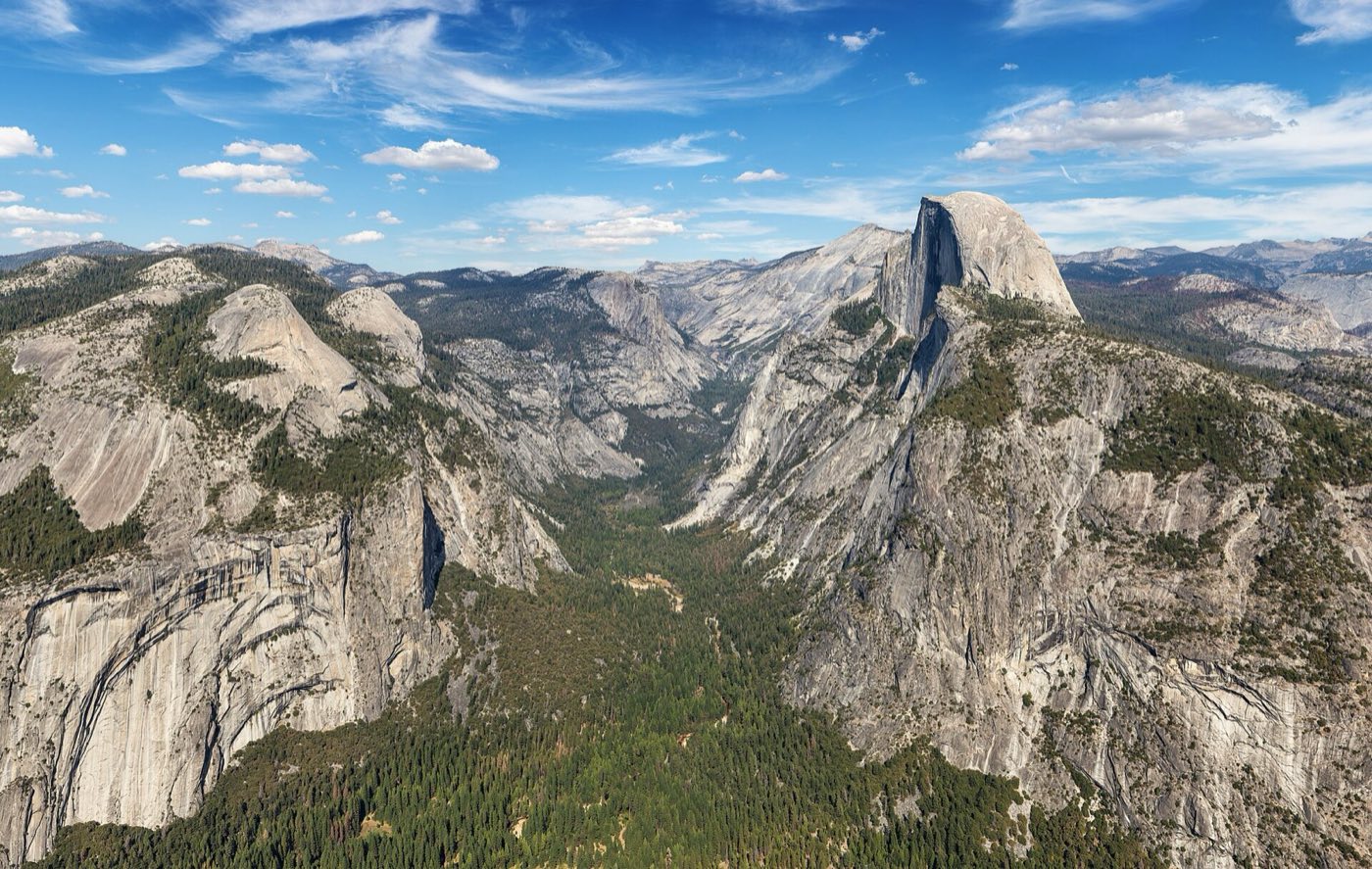
Glacier Point sunset overlooking the entire valley
The paved drive to Glacier Point (when the road is open, typically late May through October) delivers you 3,200 feet above the valley floor with Half Dome eye-level across the canyon. Time your visit for the last hour of light — the valley fills with shadow while the sun keeps hitting Half Dome's face, then turns it pink. Bring a warm layer; wind at 7,200 feet at dusk is serious even in August. The Four-Mile Trail descends from here back to the valley if you arrange a shuttle or a second car.
Mariposa Grove of giant sequoias
Thirty miles south of the valley near the south entrance, the Mariposa Grove protects about 500 mature giant sequoias, including the Grizzly Giant — 209 feet tall, estimated at 2,700 years old. The lower grove is reached by shuttle from a welcome plaza two miles away; from the end of the line, a two-mile loop visits the most famous trees. Continue up to the upper grove for fewer people and the Wawona Point overlook, about 6.5 miles round trip total. Go early — the shuttle line stretches long by mid-morning in summer.
Mirror Lake reflections of Half Dome in spring
Mirror Lake is less a lake than a seasonal pool in Tenaya Creek at the eastern end of the valley, below Half Dome's sheer north face. In April through June the water is high enough to reflect the full face; by August it's usually dry meadow. A flat two-mile round-trip path leads from the valley shuttle stop, and a full loop around it takes about five miles. Go at dawn — wind flattens the water surface, and Half Dome sits above you in the reflection almost exactly as it does in real life.
Getting There & When to Go
Fresno Yosemite International is the closest airport, about 90 minutes from the south entrance. Oakland and San Francisco are three and a half to four hours west. A timed-entry reservation is required at peak summer hours on certain dates — check the NPS site in advance, they change the rules most years. May and June hit peak waterfall flow but also peak crowds; late September and October offer golden light, fall color, and quieter trails, though some falls run dry by then. Tioga Road and Glacier Point Road typically open late May and close by November. Winter brings snow, ice-fringed falls, and the ability to snowshoe or cross-country ski the high country.
Where to Stay
Inside the park, the Ahwahnee (1927, grand lodge with a stone fireplace the size of a car) is the iconic splurge; Yosemite Valley Lodge and Curry Village offer mid-range and budget options on the valley floor. All three book out six to twelve months ahead for summer dates. Campgrounds on the valley floor are even harder — reservations open five months in advance and sell out in minutes. Outside the park, El Portal is the closest gateway with a handful of hotels just outside the Arch Rock entrance. Groveland, Mariposa, and Oakhurst all sit 30 to 45 minutes from an entrance and offer wider choice and lower prices without adding much to your commute.
Frequently Asked Questions
- Do I need a reservation to enter Yosemite?
- Sometimes. Peak-season timed-entry reservations are required on weekends and peak days in spring, summer, and fall — rules change yearly, so check nps.gov/yose before you go. Outside those windows, standard entry passes or a per-vehicle fee work without a reservation.
- Can I hike Half Dome without a permit?
- No. The cables section requires a day-hiker or backpacker permit year-round. Day-hiker permits are distributed by lottery in March via recreation.gov for the full May-through-October season, with a small number of daily lottery permits released two days in advance.
- When do Yosemite's waterfalls run dry?
- Most of the park's falls peak in May and June with spring snowmelt, then decline through summer. Yosemite Falls, Bridalveil Fall, and the smaller falls typically slow to a trickle or dry completely by August or September in normal years. Vernal and Nevada Falls run year-round because they're fed by the larger Merced River.
- How do I avoid the worst crowds in the valley?
- Stay inside the park or at the closest gateway so you're on trails by 7 a.m. before day-trippers arrive. Target Tuesday through Thursday rather than weekends. Skip Yosemite Valley during midday in July — do the high country along Tioga Road or Mariposa Grove instead, then return to the valley for the last two hours of daylight.
Plan Your Visit
Book Nearby HotelsYosemite Planning Guides
Compare focused Yosemite National Park lodging, itinerary, and activity guides before you book.
Where to stay
Where to Stay Near Yosemite National Park
Compare where to stay near Yosemite National Park, including Yosemite Valley, El Portal, Mariposa, Oakhurst, and Groveland.
Itinerary
Yosemite National Park Itinerary
Plan a Yosemite National Park itinerary for one, two, or three days with Yosemite Valley, Glacier Point, Mariposa Grove, waterfalls, and gateway towns.
Things to do
Things to Do in Yosemite National Park
Explore the best things to do in Yosemite National Park, including Yosemite Valley, Tunnel View, Mist Trail, Glacier Point, Mariposa Grove, and Tioga Road.
Have you visited Yosemite?
Track all 63 national parks on your map