National Park · CA · Est. 1940
Kings Canyon
Overview
Kings Canyon is built around a deep granite canyon carved by the South Fork of the Kings River, walls rising 8,000 feet from the riverbed — one of the last big American canyons you can drive into on a road without a gate at the end. John Muir called it a rival of Yosemite Valley. He wasn't wrong. The Kings Canyon Scenic Byway (Highway 180) drops 4,000 feet into the canyon with the river hammering below, and at the bottom you're in a Yosemite-scale valley with almost none of Yosemite's crowds. The park really has two halves. At the western entrance, around 6,500 feet of elevation, Grant Grove holds General Grant — the third-largest tree on Earth and the declared National Christmas Tree, with a ceremony held beneath its branches every December. The paved half-mile loop through the grove among the cinnamon-red trunks takes about 45 minutes. The other half is Cedar Grove, 30 miles east down Highway 180. That road is only open roughly mid-May through mid-November, depending on snow and rockfall. Plan two days to do the park right, and expect patchy cell service throughout. Sequoia shares the park's southern boundary and Generals Highway connects the two, so most road-trippers combine them.
What to See & Do
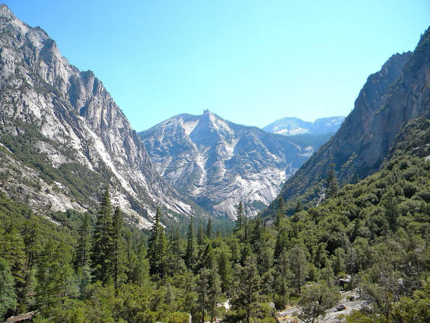
Kings Canyon Scenic Byway — one of America's most dramatic drives
Highway 180 from Grant Grove down to Road's End at Cedar Grove is 30 miles and takes about an hour without stops — but you'll stop. The road drops into Kings Canyon at Junction View, then hugs ledges above the roaring South Fork. Pull-outs at Yucca Point and Horseshoe Bend give you canyon-bottom views most visitors never see. The road is closed from about November through mid-May due to rockfall risk; even in summer, small slides occasionally close lanes. Gas up in Grant Grove before you descend — there are no services in the canyon.
General Grant Tree — the Nation's Christmas Tree and third-largest tree on Earth
General Grant stands 267 feet tall, measures 107 feet around at its base, and has been the official National Christmas Tree since 1926, with a ceremony held beneath its branches every December. The paved, half-mile Grant Tree Trail loops through the grove past the Fallen Monarch (walk through its hollow interior) and the Centennial Stump, cut as a Centennial Exhibition exhibit in 1875. Come early or late in the day — midday crowds can make the short loop feel busy — and look up constantly; the scale doesn't register at eye level.
Zumwalt Meadow walk along the Kings River
At the canyon floor near Road's End, Zumwalt Meadow is a 1.5-mile mostly flat loop through a granite-walled meadow with the Kings River running through it. The view looking upvalley — granite domes rising on both sides, green meadow, gravel bar beaches — is often compared to Yosemite's Happy Isles. Deer graze in the evening, and sunset paints the granite orange. Part of the trail has been closed in recent seasons due to rockfall; check at the Cedar Grove visitor center. Bring a swimsuit — the river pools are freezing but irresistible in August.
Mist Falls trail — the park's largest waterfall
From Road's End, the Mist Falls trail is 8 miles roundtrip with 800 feet of gain, passable for most fit walkers in 4 to 5 hours. The first two miles are flat and sandy along the Kings River; then it climbs through granite slabs to the falls, where the river pours 45 feet off a ledge into a broad pool. Late May through early July is when the falls are thundering — by August the flow drops to a trickle. Start by 7 a.m. to avoid heat and the thick midday crowds on the lower section.
Roaring River Falls, a quick walk from the road
Between the canyon entrance and Cedar Grove, a marked pullout puts you at a short paved path — about five minutes each way — to Roaring River Falls, a 40-foot cascade dropping through a granite chute into a blue pool. It's the easiest waterfall in the park to access, and it runs strong through July. Good for an after-dinner walk or if you're passing through with kids. Don't try to swim the pool; the hydraulic at the base of the falls is dangerous.
Panoramic Point overlook above Grant Grove
A short 2.3-mile paved road from Grant Grove Village climbs to Panoramic Point, a trailhead where a quarter-mile paved path takes you to a fenced overlook at 7,520 feet. From here you see east across the canyons of the Kings River watershed to the crest of the Sierra Nevada and the 14,000-foot peaks of the Great Western Divide. The best visit is clear morning in July or after the first fall snow dusts the peaks. Trailer-towing vehicles are prohibited on the narrow access road.
Rae Lakes Loop — a 41-mile backcountry circuit
Rae Lakes Loop is the classic Sierra multi-day backpacking trip — 41 miles and about 7,000 feet of cumulative gain, typically done over four or five nights. You start from Road's End, climb the Paradise Valley and the Woods Creek drainage, cross Glen Pass at 11,978 feet, and descend through the Rae Lakes basin. Wilderness permits are competitive; a daily quota system runs through the summer, and trailhead reservations open six months ahead on Recreation.gov. Bear canisters are required. Don't attempt it before July — the passes hold snow into late June.
Getting There & When to Go
Kings Canyon's western entrance at Big Stump is 55 miles east of Fresno on Highway 180, about a 90-minute drive from Fresno Yosemite International Airport. The park shares its southern boundary with Sequoia — most visitors combine the two — and the Generals Highway connects Grant Grove to Sequoia's Giant Forest in about an hour. The Kings Canyon Scenic Byway down to Cedar Grove is only open mid-May through mid-November; plan your trip around that window if you want the canyon experience. Grant Grove is accessible year-round with chains sometimes required. July and August are busiest; late September brings thinner crowds and cooler hiking weather.
Where to Stay
Inside the park, John Muir Lodge at Grant Grove (year-round) and Cedar Grove Lodge (summer only) are the two motel-style options, running roughly $200 to $300 a night and booking out well ahead for summer. Grant Grove Cabins range from tent-cabins to duplexes. The Cedar Grove Campground at the canyon bottom is the atmospheric pick — $25-ish a night, river-adjacent, open late May through mid-October. Outside the park, Three Rivers (the gateway to Sequoia, about two hours south) has more lodging but doesn't suit Kings Canyon-focused trips. Fresno offers the widest hotel inventory if you just want a bed before the early drive up.
Frequently Asked Questions
- Do I need a reservation or timed-entry pass for Kings Canyon?
- No — Kings Canyon and Sequoia do not use timed-entry reservations. The standard $35 per-vehicle fee covers both parks for seven days. Lodging and campgrounds do need reservations in peak summer, and wilderness permits for the Rae Lakes Loop and other backcountry trips book up months ahead on Recreation.gov.
- How long do I need to visit Kings Canyon?
- A full day minimum gets you through Grant Grove, a portion of the Kings Canyon Scenic Byway, and one short canyon-floor walk. Two days lets you spend a full day in Cedar Grove, do the Mist Falls hike, and see General Grant without rushing. If you're combining with Sequoia, plan three to four days total for both parks.
- When is the Kings Canyon Scenic Byway open?
- Highway 180 from Grant Grove down to Cedar Grove and Road's End typically opens in mid-May and closes in mid-November, depending on snow, rockfall, and road damage. Exact dates vary year to year — check the NPS website before you drive. The Grant Grove area and Generals Highway to Sequoia stay open year-round with seasonal chain controls.
- Are there bears in Kings Canyon?
- Yes — black bears are common throughout the park, especially around Cedar Grove campgrounds and picnic areas. Use the metal bear-proof food lockers at every campsite and trailhead; never leave food or scented items in your car overnight, even in a locked trunk. Bears in this park have a long history of breaking into vehicles for snacks, and you'll be fined if yours is the car they target.
Plan Your Visit
Book Nearby HotelsHave you visited Kings Canyon?
Track all 63 national parks on your map