National Park · CA · Est. 1994
Death Valley
Overview
Death Valley is the hottest, driest, and lowest place in North America, and visiting in the right season reshapes how you think about deserts. The valley floor at Badwater Basin sits 282 feet below sea level in a trough of cracked salt; the mountains just east rise over 11,000 feet. Summer air temperatures regularly exceed 120°F and have touched 134°F, and the National Park Service is blunt about what that can do to a visitor who underestimates it. Come in winter or spring and all of that hostile geology turns beautiful — cool hiking weather, low-angle light on banded badlands, and, after the rare wet winter, wildflower blooms that turn the valley floor yellow. What you don't expect is how varied the landscape is. In one long day you can stand on salt flats at the lowest point in the country, watch dunes glow pink at sunset, drive up a one-way canyon of Technicolor minerals, and look down from 5,475 feet at Dante's View over the whole basin. The park is also enormous — more than 3.4 million acres — and dispersed, so expect long drives between marquee sights. Bring way more water than feels reasonable (a gallon per person per day is the NPS minimum), a full tank of gas at every chance, and a plan for what you'll do if your car breaks down on an empty road.
What to See & Do
Badwater Basin salt flats at 282 feet below sea level
Badwater is the lowest point in North America, a shallow pool of undrinkable brine bordered by miles of hexagonal salt polygons cracked into the valley floor. A flat, easy boardwalk leads out to the salt, and you can keep walking a half mile or more beyond it onto the crunchy white crust. Go early in the morning to beat the heat and crowds. In the distance up the cliff wall, a small sign marks sea level — a useful reminder of exactly how far down you are. Bring sunglasses; the salt glare off the flats is intense.
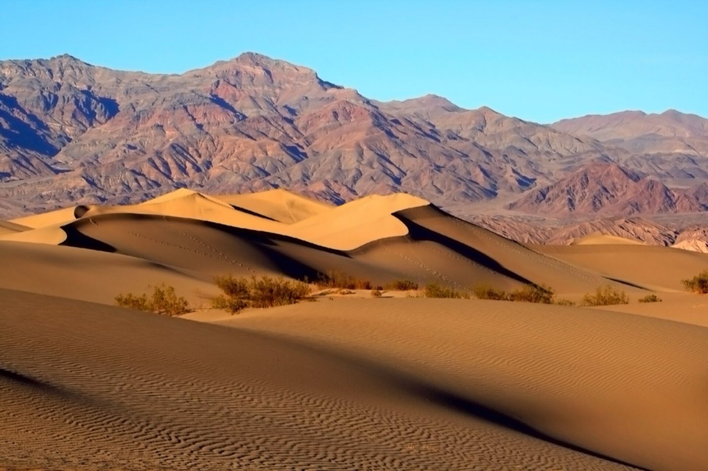
Mesquite Flat Sand Dunes at sunrise or sunset
Outside Stovepipe Wells, the Mesquite Flat dunes cover 14 square miles and reach 100 feet tall, making them the most accessible dune field in the park. Sunrise gives you long shadows and clean, unwalked sand — go with the first light and the ripples are uncut by earlier footprints. Sunset burns them orange and draws a bigger crowd. No trails; just walk out, follow a ridgeline, and come back the way you came. Rangers warn against hiking the dunes midday in any season warmer than winter.
Artist's Drive and the colorful Artist's Palette
Artist's Drive is a 9-mile one-way loop off Badwater Road that winds up into a playful section of eroded hills streaked green, pink, purple, and yellow from various metal-oxide mineral weathering. The pullout called Artist's Palette mid-loop is where the colors collect tightest. Go in late-afternoon light for strongest saturation. Vehicles longer than 25 feet aren't allowed on the drive — the curves are too tight. The whole loop with photo stops takes about an hour.
Zabriskie Point for golden badlands at dawn
A short paved walk from the parking lot climbs to Zabriskie Point, a viewpoint over a spectacular tangle of pleated, eroded badlands. First light hits them from the east and turns the whole view gold; it's the park's iconic sunrise photograph and worth the early alarm. Afterward, continue on the 2.7-mile Golden Canyon or Gower Gulch loop trails that drop off the viewpoint into the badlands themselves. Parking fills fast around dawn in peak season — arrive 30 minutes before sunrise.
Racetrack Playa's mysterious sailing stones
The Racetrack is a perfectly flat dry lakebed whose scattered rocks — some weighing hundreds of pounds — appear to have moved on their own, leaving long, straight furrows across the mud. Scientists solved the mystery recently (thin ice sheets push them under rare winter conditions), and it hasn't made the experience any less strange. Getting there is the commitment: 27 miles of rough washboard gravel road from Ubehebe Crater. High-clearance vehicles required; two spare tires recommended. Most rental-car contracts forbid it. Plan a full day.
Dante's View overlooking the entire valley from 5,475 feet
Dante's View is the best overlook in the park, a 5,475-foot perch on the Black Mountains where the entire valley basin spreads out below you. Badwater is a tiny white dot; the Panamint Range rises to 11,049 feet on the far side. It's cool up here — often 25 degrees cooler than the valley floor — and clear at sunrise. The 13-mile paved spur road from the main highway gains altitude fast and is closed to vehicles over 25 feet. Pack a wind layer even in summer.
Golden Canyon and Red Cathedral hike
Golden Canyon is one of the few canyon hikes in the park that's the perfect length — a 2-mile round-trip walks you through gold-banded narrows to Red Cathedral, a cliff wall of rust-red rock jutting skyward at the canyon head. Extending it through the connected Gower Gulch loop turns it into a 4.5-mile badlands circuit. Start early — by 9 a.m. in spring it's already hot. The canyon is closed during rare flash-flood events; ask at the visitor center before driving out.
Getting There & When to Go
The closest airport is Las Vegas, about two hours east; Los Angeles is roughly four hours southwest. From Vegas, most visitors take US-95 north and turn west at Beatty, Nevada; from LA, you drive through Ridgecrest and enter from the west. November through March is the only reasonable visiting window for outdoor time — highs in the 60s to 80s and cool nights. Spring wildflower super blooms (roughly March into April) follow wet winters; they're rare and worth rearranging a trip around. Summer is dangerous: regular 120-plus-degree highs, heat-related deaths most years, cars overheating on the passes. If you must come in summer, limit yourself to short stops near the car and drink far more than feels normal. Gas is available at Furnace Creek, Stovepipe Wells, and Panamint Springs — fill up at every chance.
Where to Stay
Inside the park, The Inn at Death Valley is the historic 1927 resort at Furnace Creek with a spring-fed pool and the park's nicest rooms; The Ranch at Death Valley, right next door, is the more casual family-friendly sibling with a larger pool, restaurants, and a general store. Stovepipe Wells Village near the dunes has motel-style rooms at a lower price, and Panamint Springs Resort on the far west side is the quietest base. Campgrounds at Furnace Creek, Stovepipe Wells, Texas Springs, and Mesquite Spring fill in winter; Wildrose and Emigrant are free and first-come. Book Furnace Creek lodging 6 to 12 months ahead for peak winter weekends.
Frequently Asked Questions
- Is it safe to visit in summer?
- Only with serious precautions. Summer temperatures regularly exceed 120°F, and the park has fatalities every year from heat and dehydration. If you must visit in summer, avoid hiking after 10 a.m., drink at least a gallon of water per person per day, never leave pets in a car, and carry extra water for a stranded-vehicle scenario. Winter through early spring is when most visitors come for a reason.
- Will I see the wildflower super bloom?
- Only in the rare years following wet winters — historically about one year in a decade. The bloom peaks roughly February through April and is unforgettable when it hits: yellow desert gold, purple sand verbena, and pink desert five-spot across the valley floor. Check the park's wildflower page in January to see what's forecast.
- Can I reach Racetrack Playa in a rental car?
- Usually no. The road is 27 miles of rough washboard and sharp rock that routinely shreds tires, and almost every rental-car agreement explicitly prohibits it. Rent a high-clearance 4WD from a Las Vegas off-road outfitter, or join a guided tour. Do not attempt in a sedan or a passenger-car rental.
- Is cell service available?
- Very limited. There's intermittent service near Furnace Creek and Stovepipe Wells, and almost none elsewhere in the park. Download maps offline, carry a paper map from the visitor center, and tell someone your itinerary. A satellite messenger is worth considering if you're doing anything off the main paved roads.
Plan Your Visit
Book Nearby HotelsDeath Valley Planning Guides
Compare focused Death Valley National Park lodging, itinerary, and activity guides before you book.
Where to stay
Where to Stay Near Death Valley National Park
Compare where to stay near Death Valley National Park, including Furnace Creek, Stovepipe Wells, Beatty, and Pahrump.
Itinerary
Death Valley National Park Itinerary
Plan a Death Valley National Park itinerary with Badwater Basin, Zabriskie Point, Artist's Drive, and safe-season timing.
Things to do
Things to Do in Death Valley National Park
Explore the best things to do in Death Valley National Park, including Badwater Basin, Zabriskie Point, Artist's Drive, and Racetrack Playa.
Have you visited Death Valley?
Track all 63 national parks on your map