National Park · CA · Est. 1890
Sequoia
Overview
Sequoia protects the largest trees on Earth by volume. The General Sherman Tree, a few hundred feet off the highway in the Giant Forest, is the single largest living organism on the planet by mass — 275 feet tall, 36 feet across at the base, and estimated to be around 2,200 years old. Standing at its foot is the kind of moment that reorganizes your sense of time. Hundreds of other giant sequoias surround it in named groves on the western slope of the Sierra Nevada, all of them measured in cubic feet of wood rather than height because nothing else competes at that scale. Generals Highway is the backbone of the park, climbing out of the Kaweah River canyon through chaparral, oak savannah, and mixed conifer until it reaches the Giant Forest at 6,500 feet, where the big sequoia groves begin. Because the road is narrow, steep, and winding, the NPS runs a summer shuttle system in the Giant Forest — ride it to General Sherman and Moro Rock rather than fight for parking. Come prepared for elevation (headaches and sleeplessness the first night are normal above 6,000 feet) and for cool nights even in July. Black bears are genuinely common here; use the bear boxes at every trailhead. Kings Canyon shares the park's northern boundary and Generals Highway connects the two, so most visitors do them as a single trip.
What to See & Do
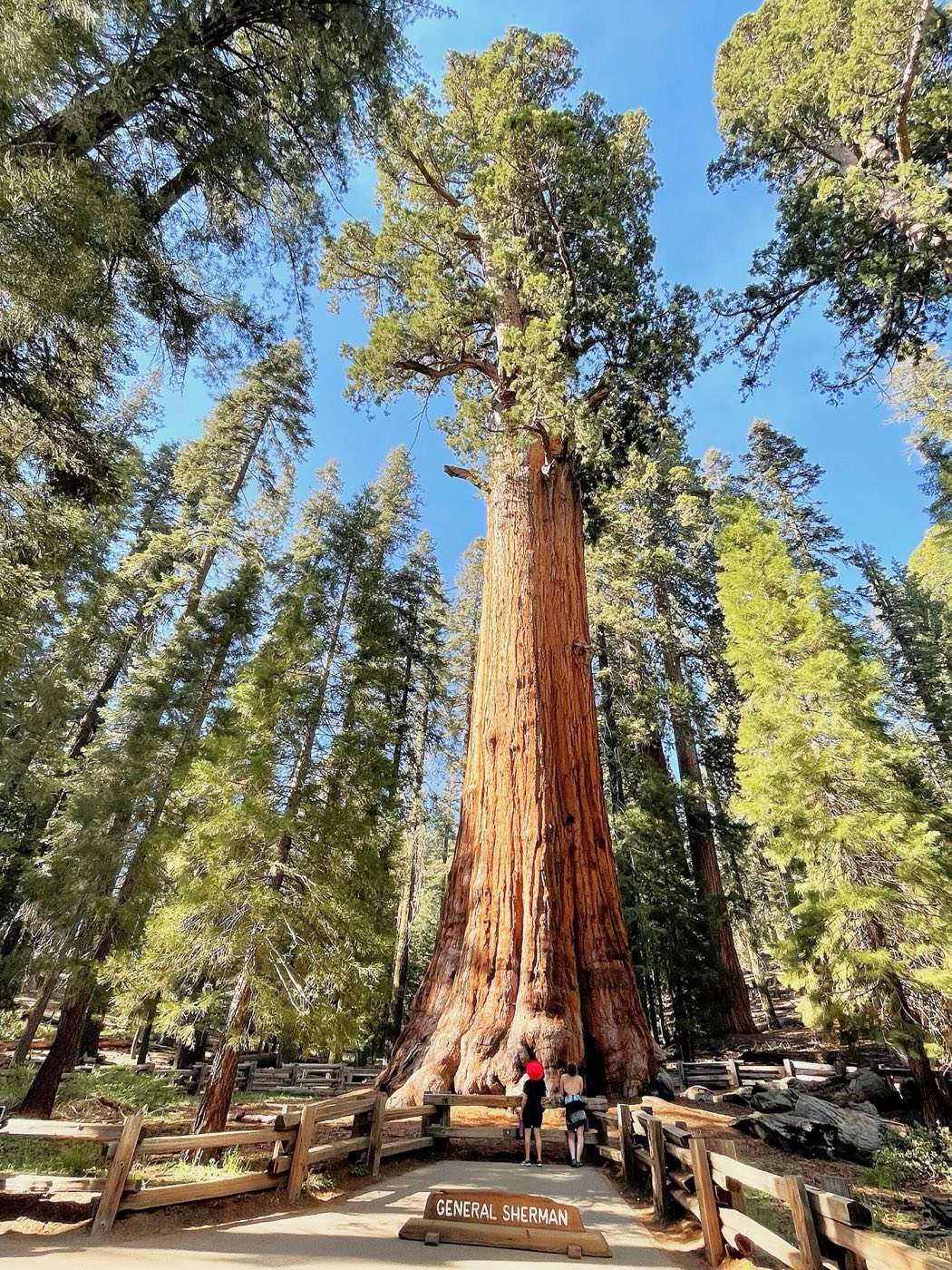
General Sherman Tree — the largest living tree on Earth by volume
A paved half-mile walk downhill from the main parking lot leads to the base of the Sherman Tree — 275 feet tall, 52,500 cubic feet of wood, and still growing about a cubic foot of new wood every year. There's an accessible upper path with a direct shuttle drop-off for visitors with mobility needs. Early morning or late afternoon avoids the crowds; midday in July the path can feel like a theme-park queue. Continue on the Congress Trail for a quieter alternative.
Congress Trail loop through Giant Forest's sequoia groves
A 3-mile paved loop starting at Sherman that winds past named groupings — the House, the Senate, the President — where sequoias cluster in cathedral-like stands. Because most visitors stop at Sherman and turn back, the loop thins out fast. Allow 90 minutes minimum, longer if you're stopping to crane your neck. The trail is mostly flat with a few gentle rises and is one of the best short hikes in the park.
Moro Rock stairway climb for Sierra Nevada panoramas
A 400-step stone-and-concrete staircase, built by the CCC in the 1930s, climbs a granite dome to a 6,725-foot summit with a 360-degree view of the Great Western Divide and the Kaweah watershed. The climb is short (quarter-mile) but steep with exposed drop-offs — not for anyone uncomfortable with heights. Access in summer is via the shuttle only, not private vehicle. Sunset from the top is spectacular; bring a headlamp for the walk back.
Crystal Cave marble cavern tour (advance tickets required)
A marble cave decorated with stalactites, stalagmites, and curtains, reached by a steep half-mile walk from the parking area. Tours run May through September and fill up days in advance — book on recreation.gov before you arrive, not at the ranger station. The cave stays 48°F year-round, so bring a jacket. The drive to the trailhead is a rough, narrow 7-mile road not suitable for RVs or trailers.
Tunnel Log — drive through a fallen sequoia
A sequoia that fell across the Crescent Meadow Road in 1937 was carved into an 8-foot-tall, 17-foot-wide tunnel that cars still drive through. It's a 60-second photo stop and a reliable kid-pleaser — line up, crawl through, take the picture, get out of the way. Anything taller than 8 feet will need to take the bypass. The nearby Crescent Meadow loop (see below) is worth the stop that sets it up.
Tokopah Falls trail along the Marble Fork of the Kaweah River
A 3.8-mile out-and-back from Lodgepole Campground, mostly flat along the river up to a 1,200-foot tiered cascade at the head of the valley. Snowmelt peaks the falls in May and June — by August the water is thin but the polished granite of Tokopah Valley remains impressive. Keep an eye out for yellow-bellied marmots sunning on rocks. The trailhead parking fills up on summer weekends; go early or park at Lodgepole Visitor Center and walk in.
Crescent Meadow — John Muir's 'Gem of the Sierra'
A 1.8-mile loop around a lush sequoia-ringed meadow that Muir called the gem of the Sierra. Wildflowers peak in July, mule deer graze at dawn and dusk, and a side trail leads to Tharp's Log, a hollowed-out sequoia a pioneer once lived in. Bears are commonly sighted here — keep distance and never leave food in the car. Accessed by shuttle in summer; the road is closed to private vehicles in peak months.
Getting There & When to Go
Fresno Yosemite International is the closest major airport, a 2-hour drive from the park's Ash Mountain entrance. Visalia is the gateway town. Late May through October is the main season, when Generals Highway is fully passable and most trails are snow-free. July and August are busy and warm at the lower elevations; June brings peak waterfalls from snowmelt. Generals Highway can require tire chains in winter and spring, and the high-country roads (Mineral King, Lodgepole) close seasonally. A summer shuttle runs through Giant Forest — use it to skip the parking stress.
Where to Stay
Inside the park, Wuksachi Lodge is the main option, a handsome lodge at 7,200 feet near Lodgepole with rooms in three buildings and a restaurant with views of the Silliman Crest. Silver City Mountain Resort in Mineral King and John Muir Lodge over in neighboring Kings Canyon are the other in-park lodges. Campgrounds include Lodgepole, Dorst Creek, Potwisha, and Buckeye Flat; reserve on recreation.gov six months ahead for summer. For more variety, Three Rivers just outside the Ash Mountain entrance has motels, cabins, vacation rentals, and restaurants — it's a 45-minute drive up to Giant Forest but a friendlier budget option.
Frequently Asked Questions
- Can I drive to the giant sequoias or do I have to take a shuttle?
- You can drive to the Giant Forest and Sherman Tree parking areas at any time, but summer parking fills by mid-morning. From late May through September, the NPS runs a free in-park shuttle that connects Lodgepole, Giant Forest Museum, Sherman Tree, and Moro Rock — Moro Rock and Crescent Meadow roads are shuttle-only in peak season.
- How do Sequoia and Kings Canyon relate to each other?
- They're two separate national parks jointly administered by the NPS and sharing Generals Highway. Most visitors do both in one trip — Giant Forest (in Sequoia) and General Grant Grove (in Kings Canyon) are about 30 miles apart and entry fees cover both. A full loop including Cedar Grove in Kings Canyon adds a scenic day.
- Are there bears, and do I need to worry?
- Yes — black bears are common, and they're smart about cars with food or even coolers left in them. Use the bear-proof boxes at every trailhead and campsite, never leave food in your vehicle overnight, and store all scented items (toiletries, trash) in a box. Bears rarely hurt visitors, but they will damage cars to get at food.
- When is Generals Highway open?
- Year-round, but tire chains are frequently required from November through April on the climb into Giant Forest, and the road can close temporarily during storms. Mineral King Road and the high-country access to Crystal Cave close November through May. Check the park road status page the morning of your drive in winter.
Plan Your Visit
Book Nearby HotelsHave you visited Sequoia?
Track all 63 national parks on your map