National Park · CA · Est. 2013
Pinnacles
Overview
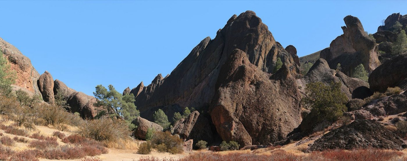
Pinnacles is the youngest national park in California and one of the strangest stories in American geology. Twenty-three million years ago, a volcanic field erupted near what's now Lancaster in Southern California. The San Andreas Fault then proceeded to tear the volcano in half and drag the western portion 200 miles north along the fault line to where it sits today, just inland of the Salinas Valley. What you see in the park — the red and tan rock spires, the talus caves formed where boulders tumbled into narrow canyons — are the eroded remains of that migrated volcanic field. The park has two entrances that don't connect: the east side, off Highway 25 near Hollister, is the main one with the visitor center, campground, and most services; the west side, off Highway 146 from Soledad, is quieter and sits closer to the High Peaks. You can't drive between them — you hike over the top, about a 6-mile crossing. Rock climbers come for the volcanic breccia, which is rough and grippy and unlike anything else in California. Everyone else comes for the caves, the condors, and the spring wildflowers. Summer is too hot for comfortable hiking; the park's real season is February through May, when the hills are green and the creek is running and the caves are cool.
What to See & Do
Bear Gulch Cave system — scramble through talus caves with a headlamp
From the east side day-use area, a 0.7-mile trail climbs to the lower entrance of Bear Gulch Cave, where you squeeze through passages formed by house-sized boulders wedged between the canyon walls. A headlamp is essential — the cave is dark, the floor is uneven, and you'll wade through shallow water in wet years. The cave closes in sections from mid-May through mid-July each year to protect a Townsend's big-eared bat maternity colony. Check the park's cave status page before you go.
Balconies Cave trail on the park's west side
From the west-side Chaparral picnic area, a 2.4-mile loop drops into Balconies Cave, a similar talus cave formed where boulders fell into the narrow canyon below the Balconies cliffs. The cave section is shorter than Bear Gulch but has a more dramatic exit — you emerge into an open canyon with climbers' walls rising on both sides. Bring a headlamp and be prepared to duck and scramble. Check cave closure dates; bats and winter flooding both affect access.
California condor spotting from the High Peaks Trail
The park is one of two release sites in California for the California condor, which was down to 22 birds in 1987 and now numbers several hundred. Wild condors with nine-and-a-half-foot wingspans ride thermals above the High Peaks most mornings and late afternoons from spring through fall. The High Peaks Trail from either side of the park puts you on the ridge where they fly. Condors have numbered tags on their wings; rangers at the visitor center can tell you which birds are currently active.
High Peaks Trail through dramatic volcanic spires
The signature hike of the park, the High Peaks loop climbs through the densest cluster of volcanic spires on either side of the range. A stretch called the Steep and Narrow Section cuts steps and railings into the cliff face — it's exposed and exhilarating. Round-trip from the east is about 6.7 miles and 1,700 feet; from the west about 5.3 miles. Go early — the ridge is fully exposed to sun, and the park bans dogs from all trails to protect condors and other wildlife.
Old Pinnacles Trail along a shaded creek bed
A flatter alternative to the High Peaks, the 5.3-mile Old Pinnacles Trail follows the Chalone Creek drainage between the east and west entrances — good if you want shade, easier terrain, or a way to connect to Balconies Cave from the east side. The trail is best in spring when the creek runs and wildflowers bloom along the banks; in late summer and fall it's dry and dusty but still one of the cooler hikes because of the occasional oak canopy.
Rock climbing on world-class volcanic breccia
Pinnacles has been a climbing destination since the 1930s, with routes up the spires and walls ranging from easy beginner pitches to overhung 5.12s. The rock — volcanic breccia — is rough and grippy in some places and crumbly in others, which is part of the park's climbing lore. Most routes are on the west side's Balconies and Discovery Walls and on the east's Bear Gulch area. The park's climbing community is friendly; stop at the east-side visitor center for up-to-date route condition info.
Spring wildflower displays in the grasslands
From mid-February through April, the grasslands at the lower elevations of the park explode into wildflower color — California poppies, lupines, goldfields, tidy-tips, purple owl's clover, and a dozen other species. The Bench Trail and the lower portions of the Condor Gulch Trail on the east side are reliably good; the west side's Prewett Point area can be spectacular in a wet year. Peak bloom varies year to year with winter rains — check the park's wildflower report before going.
Getting There & When to Go
San Jose International Airport is the closest major airport, about 75 minutes north of the east entrance. The east side, near Hollister off Highway 25, is the main access — that's where the visitor center, campground, and most trailheads are. The west side, off Highway 146 from Soledad, is quieter but has no campground and closes its gate at sunset. No road connects the two sides inside the park; you hike over. February through May is the best season, with wildflowers, running water, and comfortable temperatures. Summer routinely exceeds 100°F and most hikers avoid it. Entrance is $30 per vehicle for seven days.
Where to Stay
Pinnacles Campground, on the east side just inside the entrance, is the only lodging inside the park — a mix of tent and RV sites with hot showers and a seasonal swimming pool, bookable through Recreation.gov and busy on spring weekends. For hotels, Hollister is about 35 minutes east and has the widest range of chain motels and small inns. Soledad, on the west side, has a handful of budget motels closer to the quiet entrance. For a nicer base with access to coast wineries and the park, Monterey is 90 minutes away on the Pacific coast, and Carmel Valley offers upscale inns and ranches within reasonable drive. Paso Robles wineries are another option to the south.
Frequently Asked Questions
- Can I drive between the east and west entrances of Pinnacles?
- No — there's no road through the park. The east and west entrances are connected only by hiking trails, which run between 5 and 7 miles one-way depending on route. If you want to see both sides by car, you'll drive a 2-hour loop around the park via Highways 25, 198, and 101. Most visitors pick one side per trip.
- When do the caves close?
- Bear Gulch Cave closes in sections from mid-May through mid-July every year to protect a Townsend's big-eared bat maternity colony; the lower section often reopens in late summer while the upper section stays closed into fall. Balconies Cave can close during wet winter months when flooding is a risk. Always check the park's current cave status page before planning a visit around the caves.
- Can I see California condors without hiking?
- Sometimes, but the reliable sightings are on the High Peaks ridge, which requires hiking several miles. From the east-side visitor center parking lot you can occasionally spot condors soaring overhead, especially on warm afternoons when thermals are strongest. The Condor Gulch Overlook, 1.7 miles up the Condor Gulch Trail, is the easiest way to get into likely condor habitat with a short-to-moderate hike.
- Are dogs allowed on park trails?
- No — dogs are prohibited on all trails in Pinnacles to protect wildlife, especially the endangered California condor. Dogs are allowed only in the campground, picnic areas, parking lots, and paved roads on leash. If you're traveling with a dog, plan on someone staying back with them, or pick another park. This restriction is enforced and rangers do check.
Plan Your Visit
Book Nearby HotelsHave you visited Pinnacles?
Track all 63 national parks on your map