National Park · CA · Est. 1916
Lassen Volcanic
Overview
Lassen Volcanic is the quiet Cascade volcano park — the one most California road-trippers drive right past on their way to Crater Lake or Yosemite, which is exactly why it rewards the detour. Lassen Peak erupted in 1915, the last major eruption in the contiguous US before Mount St. Helens, and the landscape still carries the fingerprints of that explosion: a blast zone of young forest, a lake ringed by pumice, and four of the five volcano types on Earth compressed into one park. The geothermal circulation underneath is still very much alive. You'll smell Bumpass Hell before you see it — sulfur and wet heat — and the mud pots actually sound like a low pot of oatmeal coming to a boil. Above ground, the park sits high, over 8,000 feet at the pass, so the snow lingers and the wildflower season crams itself into a frantic six weeks. Come in late July or August when the corn lilies and paintbrush are at peak and the roads are finally all open. You'll share the boardwalks with a fraction of the crowd at Yellowstone, and you'll hear your own footsteps on the cinders at Cinder Cone.
What to See & Do
Bumpass Hell boardwalk through boiling mud pots and fumaroles
A three-mile round-trip trail drops into the largest hydrothermal area in the park, a 16-acre basin of boiling mud, roaring fumaroles, and turquoise pools. The boardwalks keep you inches above ground that's nearly 200 degrees Fahrenheit in places — the name comes from Kendall Bumpass, a 19th-century rancher who stepped through the crust and lost a leg to the scalding water. Go in the morning when the steam catches the light and the wind hasn't kicked up the sulfur smell yet. Plan on two hours for the walk and the full loop of the basin.
Lassen Peak summit hike (10,457 feet) for Cascade Range views
The trail to the top is only 2.5 miles each way, but it climbs 2,000 feet over loose volcanic gravel and feels twice as long above 9,000 feet. Start at the Lassen Peak trailhead before 8 a.m. — afternoon thunderstorms are common and exposed switchbacks are a bad place to be caught. From the summit you can see Mount Shasta 75 miles north on a clear day, and you'll look straight down into the shattered crater left by the 1915 eruption. Bring more water than you think you need.
Kings Creek Falls trail through alpine meadows
A three-mile round-trip through wildflower meadows that drops to a 30-foot cascade running down a stepped lava ledge. The first half is easy meadow walking — corn lilies, lupine, and paintbrush in July and August — and the second half is a rocky descent to the falls. The cascade itself runs hardest in June when the snowpack is melting, and by September it's a trickle. A parallel return loop through the meadow avoids doubling back.
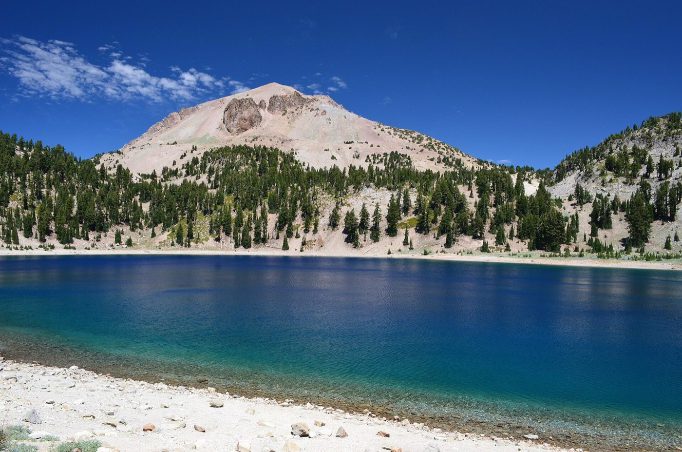
Manzanita Lake for canoeing and Lassen Peak reflections
Just inside the northwest entrance, Manzanita Lake gives you the postcard shot — Lassen Peak mirrored in glassy water, usually before 8 a.m. before the wind picks up. Rent a kayak or canoe at the camper store and paddle the one-mile loop along the shore. The lake is stocked with rainbow trout, catch-and-release only with barbless hooks, and otters, osprey, and bald eagles work the same water you're fishing. Great family stop.
Sulphur Works roadside geothermal area
The easiest thermal feature in the park — pull off the main highway a mile past the southwest entrance and you're looking at boiling mud pots and sulfur vents from a short boardwalk. Go if you don't have time for the Bumpass Hell hike, or as a warm-up to it. The smell is intense and the ground temperatures are real, so keep a firm grip on anyone under ten. Fifteen minutes is enough to see the whole area.
Cinder Cone and the Painted Dunes
A different side of the park, accessed from the Butte Lake entrance on the northeast corner. The four-mile round-trip climbs 800 feet up a perfect volcanic cone of loose black cinders — two steps up, one slide back — and at the top you can look down into a double crater and out over the Painted Dunes, rust-orange ash fields colored by oxidized iron. The hike is exposed and hot by midday; start early and bring sun protection.
Devastated Area interpretive walk through the 1915 blast zone
A paved half-mile loop across the slope where the 1915 eruption flattened the forest and hurled boulders the size of cars. Interpretive signs explain the pyroclastic flow and the lahar that followed, and the young lodgepole forest growing back gives you a sense of how life returns after a mountain blows up. An easy stop with payoff — good for anyone traveling with kids or grandparents who aren't up for the longer trails.
Getting There & When to Go
Redding, California, is the closest major airport, about an hour west of the park's southwest entrance on Highway 36. Sacramento is three hours south and usually cheaper to fly into. The 30-mile park highway — officially Highway 89 — connects the southwest entrance to the Manzanita Lake area in the northwest, and it's only fully plowed and open from late June through October. Snow regularly closes sections into July. Come in late July through August for wildflowers at peak and every trail accessible; September is quieter with the first golden aspens. Winter closes the main road, but the southwest entrance stays open for snowshoeing and cross-country skiing from a small ski area near the visitor center.
Where to Stay
Inside the park, the Manzanita Lake Campground is the big one — 179 sites, reservable through recreation.gov, and the cabins at Manzanita Lake give you roofed-over lodging with no running water for under $90 a night. Drakesbad Guest Ranch in the Warner Valley is a rustic full-service lodge with a hot-springs-fed pool, the only in-park hotel, and it books out a year ahead. Outside the park, Chester on the south side and Mineral near the southwest entrance have small motels and cabin rentals. Redding has the most options and chain hotels, but it puts you an hour from the trailheads — fine for one night, less ideal if you want a 7 a.m. start at Bumpass Hell.
Frequently Asked Questions
- Is Lassen Peak still an active volcano?
- Yes — the US Geological Survey classifies Lassen as an active volcano with a high threat potential. The 1915 eruption was the most recent major event, but the hydrothermal features throughout the park are direct evidence of ongoing magma activity beneath the surface.
- Can I do Lassen as a day trip from Redding or Sacramento?
- From Redding, yes — you can drive the highway, hit Bumpass Hell, and be back by evening. From Sacramento it's a long day at three hours each way. Better to overnight in Chester, Mineral, or Manzanita Lake so you can hit the trails at dawn before afternoon thunderstorms build.
- When is the park highway open?
- The full 30-mile Highway 89 through the park is typically open from late June or early July through late October, depending on snowpack. The southwest entrance stays open year-round for winter recreation; the Manzanita Lake side often stays drivable through early November.
- Are the thermal areas safe to visit with kids?
- On the boardwalks, yes — Sulphur Works and the Bumpass Hell basin are fenced and boarded. Off the boardwalks, the ground crust is thin and water temperatures can cause instant third-degree burns. Keep children within arm's reach at all thermal features and stay on every marked path.
Plan Your Visit
Book Nearby HotelsHave you visited Lassen Volcanic?
Track all 63 national parks on your map