National Park · OR · Est. 1902
Crater Lake
Overview
Crater Lake is the bluest thing you'll ever see. Seventy-seven hundred years ago, the 12,000-foot volcano known today as Mount Mazama collapsed on itself after a massive eruption; snowmelt and rainfall slowly filled the resulting six-mile-wide caldera over the next several centuries. Because no rivers flow in or out, the water is extraordinarily pure — visibility can reach 140 feet, and the lake absorbs all colors of visible light except for a deep, almost artificial-looking blue. Driving up from the Klamath Basin, you have no warning of it. The road climbs through fir and hemlock and then, at the rim, the land just ends and the blue appears below you like something pasted in. Rim Village and the 33-mile Rim Drive give you the big views, but what makes Crater Lake different from other volcanic parks is how often you're above the weather — the caldera makes its own, and summer afternoons can go from bluebird to thunderhead in 40 minutes. You'll want warm layers even in July, sunscreen at any elevation up here, and patience for a park where most of the roads close under 40-plus feet of snow from October through June.
What to See & Do
Rim Drive's 33-mile scenic loop with 30+ overlooks
Rim Drive circles the entire caldera on a narrow, winding, high-altitude road with more than 30 marked pullouts. Allow three to four hours minimum, ideally most of a day, and drive clockwise from Rim Village so the lake is on your left — passing cars is easier that way. Key stops include Discovery Point, Cloudcap Overlook (the highest paved road in Oregon at 7,960 feet), Phantom Ship Overlook, and Cleetwood Cove trailhead. The road typically opens in full by mid-July and closes with the first big snowstorm in October.
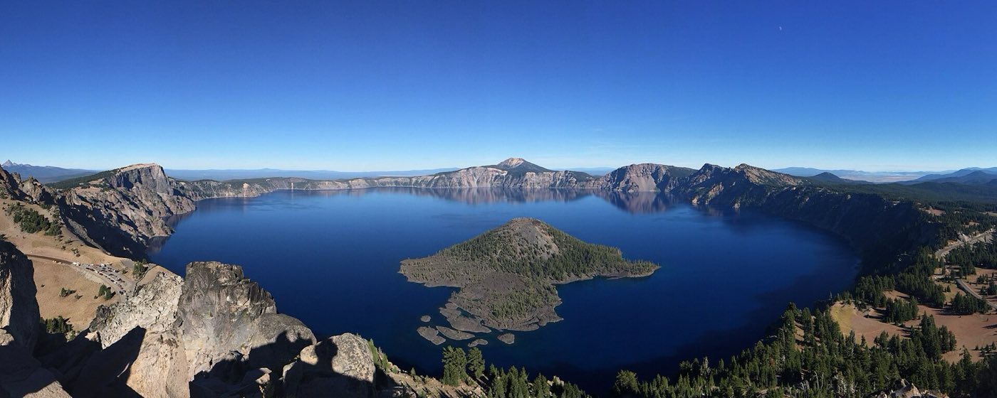
Boat tour to Wizard Island's volcanic cone summit
The park concessionaire runs boat tours from Cleetwood Cove out to Wizard Island, the cinder cone that rose from the caldera floor after the original collapse. You can take a straight lake tour or — much better — the drop-off tour that leaves you on the island for a few hours to climb the cone. The summit trail is 1.1 miles one-way and gains 750 feet; the crater at the top is rimmed with whitebark pine. Tours run mid-July through mid-September only and book out fast on Recreation.gov.
Cleetwood Cove Trail — the only route down to the lakeshore
This is the single trail in the park that reaches the water. It's 1.1 miles each way, drops 700 vertical feet down switchbacks, and going back up feels a lot longer. The reward is swimming in some of the clearest water in the world — fearsomely cold, but people do it. This is also where you catch the Wizard Island boats. Give yourself at least 90 minutes for the hike alone, and more if you plan on swimming. The trail closes most years from October through June under snow and maintenance.
Watchman Peak trail for the classic Wizard Island photo
A moderate 1.6-mile round-trip trail climbs 400 feet to a 1932-era fire lookout on Watchman Peak, delivering the most photographed angle of Wizard Island and the full sweep of the caldera. Go at sunset — the west rim catches last light across the lake, and the blue water goes molten gold. The trail's often snowbound into July. Bring a wind layer; the summit is exposed and cold even in August.
Phantom Ship rock formation rising from the lake
A 500-foot-long island of 400,000-year-old lava, Phantom Ship is the oldest exposed rock in the park — older than the caldera itself. From water level it looks like a ghostly sailing ship with rigging of weather-twisted hemlocks. You can see it clearly from the Phantom Ship Overlook on Rim Drive, but the boat tour passes within a few hundred feet and gives you the full scale. Morning light renders it best; afternoon haze tends to wash it out.
Sun Notch viewpoint for Phantom Ship framing
A short, easy half-mile loop from the Rim Drive reaches Sun Notch, a U-shaped glacial valley in the caldera rim that frames Phantom Ship perfectly from above. The trail climbs gently through wildflower meadows in July and August — lupine, Indian paintbrush, arrowleaf balsamroot — and finishes at an exposed cliff edge with a hard guardrail. It's the most photographer-friendly short walk on the whole drive and takes most visitors under an hour.
Plaikni Falls Trail through wildflower meadows
Plaikni Falls is an easy 2-mile round-trip walk on a wide, gently graded trail that climbs through old-growth hemlock to a 20-foot spring-fed waterfall tumbling over a cliff. The back half of the trail crosses meadows soaked with monkeyflower and paintbrush in July. This one works well for mixed-ability groups and is often snow-free earlier than the rim trails. Start at the Pinnacles Road turnoff on the east side of the park.
Getting There & When to Go
The closest airports are Medford, Oregon, about 90 minutes southwest, and Klamath Falls, about an hour south. Eugene and Portland are both roughly a four-hour drive. From mid-July through late September, the full Rim Drive is open and the boat tours run; this is the only window when you get the complete park experience, so plan around it. Winter is startling — deep snow, a quiet south rim still reachable by plowed road, and cross-country skiing along the south portion of the rim. The park receives an average of 43 feet of snow a year, which closes the north entrance and most of Rim Drive from October to early summer. The gates never close — just the roads.
Where to Stay
Inside the park, Crater Lake Lodge on the rim is the 1915 historic option, with wood-beamed rooms and a wraparound porch looking down into the caldera; it's open roughly late May through mid-October and books out 12 months ahead through the park's concessionaire. The Cabins at Mazama Village, 7 miles south of the rim, are more basic and a better value, open roughly June through September. Campgrounds at Mazama and Lost Creek round out the in-park options. Outside the park, the town of Prospect 30 minutes southwest has a handful of inns and lodges, and Klamath Falls an hour away has the full chain-hotel lineup with better summer availability.
Frequently Asked Questions
- When can I drive the full Rim Drive?
- Usually from mid-July through the first heavy snow in October, roughly a three-month window. The West Rim Drive from Rim Village to the North Entrance typically opens earlier in summer than the East Rim. Check the park's road status page the morning of your visit — opening dates shift with each winter's snowpack.
- Can I swim in the lake?
- Yes, but only at Cleetwood Cove — the one legal lake access point. The water stays around 55°F at the surface even in August and drops sharply a few feet down, so most swimmers jump in, swim 30 seconds, and scramble out. Pets are not allowed on the Cleetwood Cove Trail.
- Is Wizard Island worth the extra cost?
- If the weather cooperates and you can hike a steep mile, yes. Standing on a small volcanic cone in the middle of a collapsed giant volcano is a rare experience, and the summit views are the best angle on Crater Lake you'll ever get. Tours run only mid-July through mid-September and often sell out weeks ahead.
- How long do I need at the park?
- A full day is enough to drive Rim Drive with stops and hike one short trail. Two days lets you add the Cleetwood Cove hike and a boat tour, which is the difference between seeing the lake and actually being on it. Three days is ideal if you want Wizard Island plus a couple longer hikes like Watchman or Garfield Peak.
Plan Your Visit
Book Nearby HotelsHave you visited Crater Lake?
Track all 63 national parks on your map