National Park · HI · Est. 1961
Haleakalā
Overview
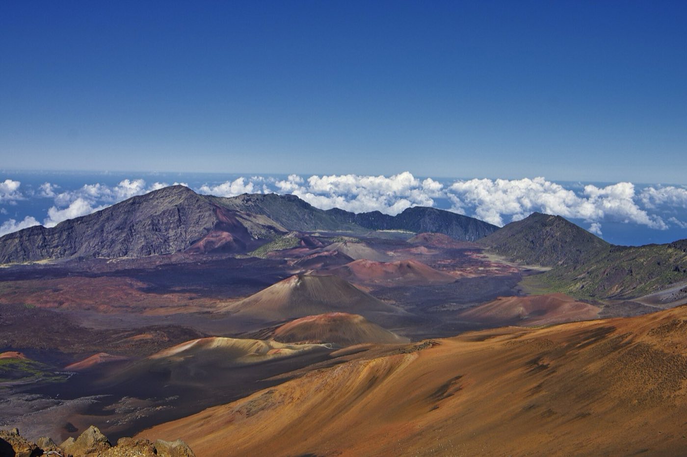
Haleakalā is the massive shield volcano that makes up three-quarters of the island of Maui — more than 10,000 feet from summit to sea and still considered active, though it hasn't erupted since the late 1700s. The park splits into two completely different districts that share a name and little else: the Summit District, a lunar volcanic crater above the clouds, and the Kīpahulu District on the island's rainy southeast coast, accessed by the famous Road to Hana. The summit is what most people come for, specifically sunrise from the 10,023-foot peak when the sun breaks the cloud layer below you and lights the crater's cinder cones in reds and oranges. Ancient Hawaiians considered this the place where the demigod Māui lassoed the sun; the Native Hawaiian name translates to House of the Sun. Sunrise visits now require a reservation, and the summit can be 30 to 50 degrees colder than the beach — people routinely show up in shorts and freeze. The other side of the park, Kīpahulu, is tropical — waterfalls, bamboo groves, and the pools of Oheʻo at the coast. Plan them as separate excursions; the drive between them takes most of a day each way.
What to See & Do
Sunrise from the 10,023-foot summit above the clouds
Haleakalā sunrise requires an advance reservation through recreation.gov, released 60 days in advance at 7 a.m. Hawaii time and gone within minutes. Entry is permitted from 3 a.m. to 7 a.m. for the reservation holder. The drive from sea level takes two hours and gains two miles of elevation, so plan leaving Kahului around 3 a.m. Temperatures at the summit run 30 to 50 degrees colder than your beach hotel; bring hats, gloves, and layers, and be ready for wind. The visitor center parking fills fast; arrive early.
Sliding Sands Trail descent into the volcanic crater
Sliding Sands (Keonehe'ehe'e) drops from the summit visitor center into the crater — a surreal landscape of red and black cinder cones that looks like Mars with a sky. A roundtrip to Ka Lu'u o ka 'O'o (2 miles down, 1,400 feet of climb back) is a reasonable day hike. Go deeper only if you're prepared for a long, grueling climb back at altitude. The crater floor is 20 square miles and a full traverse takes two days with a backcountry permit. No water, no shade, altitude effects are real.
Silversword plants
The Haleakalā silversword (ʻāhinahina) grows nowhere else on Earth — a rosette of silvery sword-shaped leaves that lives for up to 90 years, then sends up a single stalk of purple flowers and dies. The best viewing is at the Kalahaku Overlook and along the Sliding Sands Trail's upper section. Stay on the trail: the plants' shallow root systems are destroyed by footsteps, and the species nearly went extinct from trampling before park protection. Photograph from a respectful distance.
Kīpahulu District's Pīpīwai Trail through bamboo forest
The Pīpīwai Trail in the coastal Kīpahulu District is a 4-mile roundtrip through a dense, clacking bamboo grove to the base of Waimoku Falls. The bamboo section is the magic — a green tunnel where light filters through 20-foot stalks and the wind makes the canes rattle together. The trail has some steep sections and can be muddy after rain. Reach Kīpahulu via the Road to Hana; the drive is the whole day's commitment, not a quick side trip.
Waimoku Falls
Waimoku Falls is the reward at the end of the Pīpīwai Trail — a 400-foot ribbon cascade dropping off a volcanic cliff into a pool surrounded by ferns and bamboo. Don't swim or stand directly beneath the falls; rocks fall with the water and injuries happen. The Pools of Oheʻo (Seven Sacred Pools) at the coast, once a swimming attraction, have been closed to swimming for years because of flash flood risk and rockfall. Check the visitor center for current status.
Summit stargazing above the cloud layer
Haleakalā's summit sits above most atmospheric water vapor, which is why the research observatories are perched there. On a clear night the Milky Way is extraordinary — denser and more three-dimensional than almost anywhere accessible by paved road. Rangers occasionally run evening astronomy programs; check the schedule at the visitor center. Bring serious warm clothes and a red-filtered flashlight. Altitude and darkness together require care on the drive back down.
Cycling the 38-mile descent from summit to sea level
Several licensed outfitters run guided downhill cycling tours from the summit (or from the park boundary at 6,500 feet — the NPS no longer allows commercial tours to start from the actual summit). You ride specialized bikes with upgraded brakes down Haleakalā Highway's long switchbacks to sea level, a descent of more than a mile. Pick a reputable outfitter; inexperienced riders have died on this road. Dress warmly at the top and peel layers as you drop through climate zones.
Getting There & When to Go
Maui's main airport is Kahului (OGG), about 90 minutes from the summit entrance via Highway 37 and 378 through upcountry Kula. The Kīpahulu District is reached via the Road to Hana from Kahului — figure three to four hours of driving each way on a narrow, winding coast road. The park is open year-round; weather at the summit is cold and windy any season, and cloud cover is common — you need to be above the inversion layer (usually 6,000-8,000 feet) to be in the clear. Sunrise reservations are required every day of the year, released 60 days in advance and typically sold out within minutes. Daytime entry after 7 a.m. requires no reservation.
Where to Stay
There's no lodging inside the park. Most visitors stay on Maui's west side (Lahaina, Kaanapali, Kapalua) or the south shore (Kihei, Wailea) and make the sunrise drive in the dark. Upcountry Kula and Makawao, on the volcano's slopes, cut an hour off that drive and have a handful of bed-and-breakfasts and vacation rentals — a smart choice if sunrise is your priority. For Kīpahulu, the town of Hana has the Hana-Maui Resort, a few small inns, and vacation rentals; staying overnight in Hana turns the Road to Hana from a rushed day trip into a proper exploration. The park has two small campgrounds: Hosmer Grove at the summit and Kīpahulu Campground at the coast, both first-come-first-served.
Frequently Asked Questions
- Do I need a reservation for sunrise at Haleakalā?
- Yes — every day, year-round. Reservations cost $1 plus the $30 park entrance fee and are released on recreation.gov 60 days in advance at 7 a.m. Hawaii time. They sell out within minutes. Limited leftover permits release at 7 a.m. two days in advance. Without a reservation, you cannot enter the summit area between 3 a.m. and 7 a.m.
- How cold does it get at the summit?
- Summit temperatures at sunrise typically run 30 to 45 degrees Fahrenheit year-round, with wind chill often pushing the felt temperature into the 20s. People routinely show up in beach clothes and suffer. Wear long pants, closed-toe shoes, a warm jacket, a hat, and gloves. Pack a wool blanket if you're prone to being cold.
- Can I see sunrise and also visit Kīpahulu in the same day?
- Technically yes, but the logistics are brutal — after sunrise you'd drive back to Kahului, then start the three-to-four-hour Road to Hana to reach Kīpahulu, and then the return drive. It makes for a 16-hour day. Most visitors split them across two separate days; sunrise one day, Hana and Kīpahulu on another.
- Are the Pools of Oheʻo (Seven Sacred Pools) open for swimming?
- Not reliably. The pools have been closed to swimming for extended periods due to flash flood risk and rockfall hazard. Check the park website for current status before you plan your visit. Even when open, flash floods can arrive with no warning from rain falling upstream in sunny coastal weather; heed closure signs.
Plan Your Visit
Book Nearby HotelsHave you visited Haleakalā?
Track all 63 national parks on your map