National Park · HI · Est. 1916
Hawaiʻi Volcanoes
Overview
Hawaiʻi Volcanoes on the Big Island is the most active volcanic landscape on Earth, and a visit feels like watching the planet under construction in real time. Kīlauea, the younger of the park's two active volcanoes, has been erupting on and off for decades, including a dramatic multi-year eruption that reshaped the southeast coast and destroyed hundreds of homes outside the park in 2018. Since December 2020 the summit caldera has had intermittent lava lake activity; check the park's current conditions page before you go. What makes this park unusual is how much you can experience from a car or a short walk. Crater Rim Drive loops 11 miles around Kīlauea's summit caldera with pullouts at steam vents, sulfur banks, and the dramatic Halemaʻumaʻu crater overlook, where lava glow is sometimes visible after dark. Chain of Craters Road drops 3,700 feet from the rim to the coast, passing hardened lava flows from dozens of past eruptions and ending at a sea-arch formed by the surf working old lava rock. Elevations range from sea level to 13,681 feet (Mauna Loa), so you can drive from rainforest to desert to alpine zone in an hour. Bring rain gear; the summit area of Kīlauea gets 120 inches a year.
What to See & Do
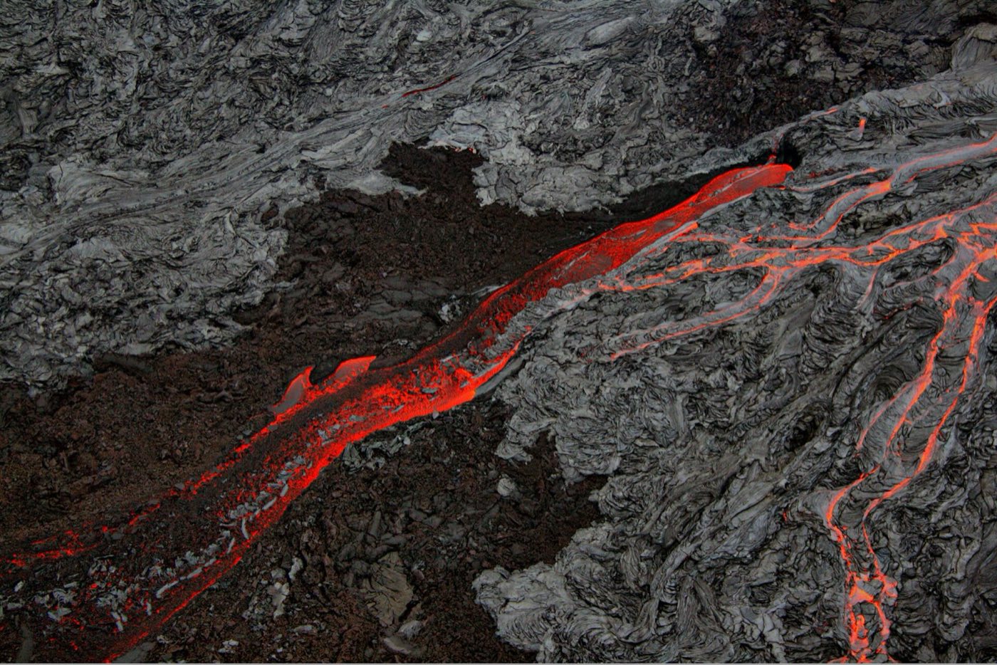
Halemaʻumaʻu crater glow at night
When Kīlauea is erupting, the orange glow of lava inside Halemaʻumaʻu crater is visible from overlooks along Crater Rim Drive after dark — most reliably from the Keanakākoʻi Overlook at the end of the closed-off old Crater Rim Drive, a 30-minute walk from the trailhead near Devastation Trail. Eruption activity varies; check the USGS Hawaiian Volcano Observatory updates before you drive. When it's going, arrive an hour after sunset as crowds thin, and bring a red-filtered headlamp.
Thurston Lava Tube (Nāhuku) walk through a lit cave
Nāhuku is a 500-year-old lava tube carved by a river of molten rock that drained away when the eruption stopped, leaving a tunnel big enough to walk through standing up. A short paved loop takes you through the lit section in about 20 minutes. The parking lot fills by 10 a.m.; arrive early or late. The surrounding rainforest trail through hapuʻu tree ferns adds another dimension and is worth the detour. The tube itself is dripping wet and cool even in summer.
Crater Rim Drive around Kīlauea's summit caldera
Most of Crater Rim Drive — about seven of the 11-mile loop — remains open after closures from past eruptions and seismic damage. Key stops include Steam Vents (rising steam where groundwater contacts hot rock), Sulphur Banks (yellow mineral deposits), the Kīlauea Visitor Center, Volcano House hotel overlook, and Uēkahuna summit overlook for the best crater view. The closed section includes Jaggar Museum, destroyed in 2018. Allow two to three hours with stops.
Chain of Craters Road descending to the coast
Chain of Craters Road drops 3,700 feet over 19 miles from the summit rim to the sea, passing multiple volcanic craters and crossing lava flows from different eras. The road ends abruptly where a 2003 flow buried it — the arch-shaped Hōlei Sea Arch is the highlight at the coastal end, though the arch itself collapsed in 2022 and the overlook now looks out over the new coastline. Allow three hours roundtrip; gas up before you leave the rim, as there's nothing at the coast.
Devastation Trail
A 1-mile one-way paved trail across the cinder field blasted out by Kīlauea Iki's 1959 eruption. The landscape still looks lunar — bare black and rust-red cinder, scattered tree skeletons, and new vegetation slowly returning. Walking across it gives you a visceral sense of what the eruption did in three and a half weeks of activity. The trail connects to the closed section of Crater Rim Drive and extends your walk toward Keanakākoʻi Overlook if you want more.
Kīlauea Iki Trail across a solidified lava lake
The Kīlauea Iki Trail is the park's signature day hike — 4 miles roundtrip that drops 400 feet into a crater floor that was a boiling 400-foot-deep lava lake in 1959. Steam vents still hiss through cracks in the hardened surface. Start at the Kīlauea Iki Overlook, descend through rainforest, cross the crater floor, and climb out the far side. About two to three hours at a steady pace. The crater floor is exposed and hot even on cool days.
Petroglyphs at Puʻu Loa along the coastal road
Puʻu Loa on Chain of Craters Road contains more than 23,000 petroglyphs pecked into hardened pāhoehoe lava by Native Hawaiians over centuries — one of the largest petroglyph fields in Hawaii. A 1.4-mile roundtrip trail leads to a boardwalk that protects the site while letting you see the images. Do not walk on or touch the petroglyphs; the boardwalk is there for a reason. Bring water; the trail has no shade and the lava radiates heat.
Getting There & When to Go
Hilo International Airport is the closest, about 45 minutes from the park entrance via Highway 11. Kona International (on the dry west side) is about two hours via the same highway — many visitors fly into Kona, tour the park as a long day trip, and stay in Kona or Hilo. The park is open 24 hours a day, 365 days a year, and entry does not require a reservation. Weather at Kīlauea's summit is cool and wet year-round; at the coast it's tropical and hot. Any season works, but volcanic activity is the variable — check the USGS Hawaiian Volcano Observatory and the park's current conditions page before you commit. Lava glow is most visible after dark, so plan for at least one evening visit.
Where to Stay
Volcano House, perched on the rim of Kīlauea caldera, is the only hotel inside the park and has the best night-glow viewing location. Rooms book months ahead. The tiny village of Volcano just outside the park has a handful of bed-and-breakfasts, cabins, and vacation rentals in the rainforest. Hilo, 30 miles away, has the widest range of hotels on the east side of the Big Island. Kona, two hours west, makes sense only if you're staying there for beach reasons and doing the park as a long day trip. The park's two campgrounds, Nāmakanipaio and Kulanaokuaiki, offer first-come-first-served camping; Nāmakanipaio is run by Volcano House and has cabins available.
Frequently Asked Questions
- Is Kīlauea currently erupting?
- It varies — Kīlauea has had intermittent eruptions within Halemaʻumaʻu crater since December 2020, with activity pausing and restarting multiple times. Check the USGS Hawaiian Volcano Observatory website and the park's current conditions page before you visit. Even when there's no surface lava, the park's other features and geology remain fascinating.
- Can I walk on lava in the park?
- You cannot walk on active flowing lava — active flows, when they happen, are in closed areas because the crust is deceptively thin over molten rock that's thousands of degrees hot. You can absolutely walk on hardened old flows, which is most of the park. Stay on marked trails; ground cracks and unstable surfaces cause injuries every year.
- How do I see the lava glow?
- When an eruption is active, the orange glow of lava in Halemaʻumaʻu crater is visible from overlooks along Crater Rim Drive after dark. The most reliable viewpoint lately has been Keanakākoʻi Overlook via a 30-minute walk from the trailhead near Devastation Trail. Arrive an hour after sunset, bring a red-filtered headlamp, and dress warmly — summit nights are cold.
- Is Hawaiʻi Volcanoes and Haleakalā the same park?
- No — they're two separate national parks on two different islands. Hawaiʻi Volcanoes is on the Big Island and is the world's most active volcanic landscape. Haleakalā is on Maui and centers on a dormant shield volcano famous for sunrise views. Both are worth visiting but require separate interisland flights and several days each.
Plan Your Visit
Book Nearby HotelsHave you visited Hawaiʻi Volcanoes?
Track all 63 national parks on your map