National Park · WA · Est. 1938
Olympic
Overview
Olympic is less one park than three stitched together — a temperate rainforest on the west side, a wild Pacific coastline running nearly 70 miles unbroken, and a range of glaciated alpine peaks in the middle. Very few parks in the world let you tide-pool at dawn, walk through moss-dripping old growth at lunch, and look down on a mountain skyline by dinner. Olympic does. The park sits on Washington's Olympic Peninsula, a thumb of land pushed west into the Pacific by the Juan de Fuca plate. Driving around it takes most of a day — Highway 101 loops the peninsula and touches every corner — and the interior has no through-road, which is why the three ecosystems feel so separate. The Hoh Rain Forest receives 12 to 14 feet of rain a year, which explains the moss; Hurricane Ridge, 45 minutes above Port Angeles, holds snow into July; and the beaches between them are full of sea stacks, driftwood the size of shipping containers, and tide pools alive with ochre sea stars. Come with a rain shell no matter the month, and plan at least three full days to see each side of the park without rushing.
What to See & Do
Hoh Rain Forest's Hall of Mosses trail
The one-mile Hall of Mosses loop out of the Hoh Visitor Center is the classic temperate rainforest walk — maple trees draped in eight-foot curtains of club moss, Sitka spruce the thickness of small cars, and a silence you only hear in old growth. Go early on summer mornings to beat the parking line; the lot fills by 10 a.m. in July and August. If you want more, the Spruce Nature Trail across the parking lot is equally good and almost always empty. Rain gear is essential — even in August.
Rialto Beach and Hole-in-the-Wall sea arch
A mile and a half of tide-flat walking from the Rialto Beach parking lot brings you to Hole-in-the-Wall, a sea arch you can walk through at low tide and look up through at high. Tide-pool on the rocks around it for sea stars, anemones, and hermit crabs. Check the tide chart before you go — high tide cuts off the beach and the return walk — and allow a three-hour round-trip window centered on low tide. Watch for bald eagles fishing off the sea stacks.
Hurricane Ridge alpine meadows and mountain panoramas
A 17-mile paved road climbs from Port Angeles to 5,242 feet at Hurricane Ridge, where meadows of lupine and paintbrush open onto the serrated wall of the Olympic Mountains. The short paved path near the visitor center gives you the view; the Hurricane Hill Trail extends it another 1.6 miles to a panoramic summit. In winter the road stays open (when avalanche conditions allow) for a small ski area — the only one operating inside a national park in the lower 48.
Sol Duc Falls trail through old-growth forest
Off Highway 101 on the park's west side, the 1.6-mile round-trip to Sol Duc Falls walks under old-growth hemlock and cedar to a dramatic three-channel waterfall that drops into a narrow gorge. It's one of the best short hikes in the park — accessible to most walkers, reliably rainy-forest beautiful, and ending with a photograph you've seen on postcards. The adjacent Sol Duc Hot Springs Resort has pools fed by the same geothermal system, which is worth a stop afterward.
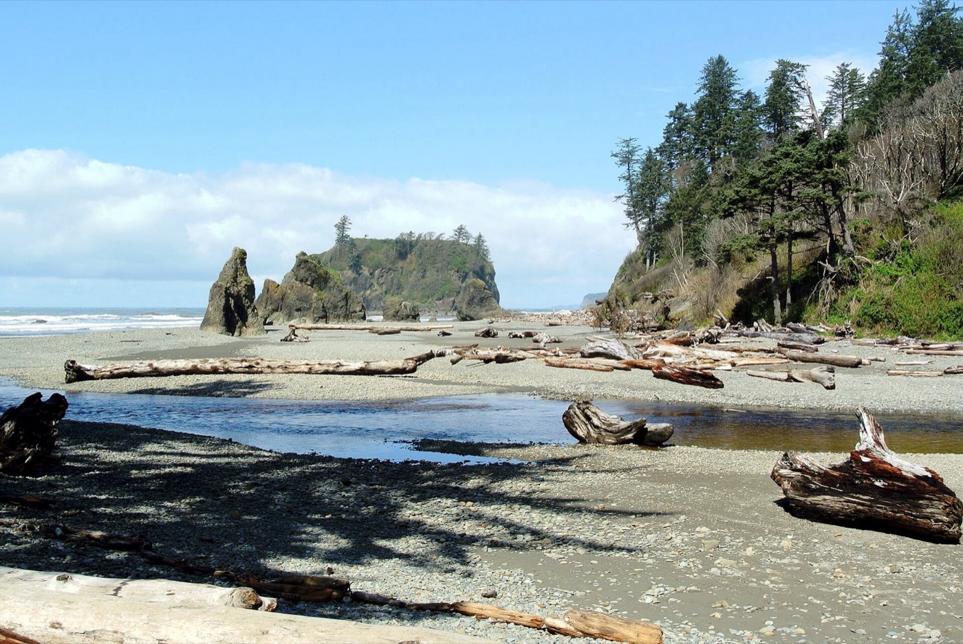
Ruby Beach sea stacks at sunset
Off Highway 101 on the southern stretch of the park's coast, Ruby Beach is a 15-minute walk from the parking area down through driftwood to a beach dominated by Abbey Island and a scatter of smaller sea stacks. Late afternoon and sunset are the magic hours — the western light throws the stacks into silhouette and the tide often recedes enough to expose tide pools. Pack a headlamp for the walk back up; the driftwood trail gets dark fast after the sun drops.
Marymere Falls near Lake Crescent
An easy 1.8-mile loop from the Storm King Ranger Station on the shore of Lake Crescent climbs gently through old growth to 90-foot Marymere Falls. Good for kids, tired hikers, or a rainy-day backup — the rainforest canopy keeps most drizzle off you. Combine with a drive around Lake Crescent, whose impossibly clear water fills a glacier-carved basin, and a meal at Lake Crescent Lodge, a 1915 lodge with a lakeside lawn made for lingering.
Tide pooling at Second Beach and Third Beach
Just south of the Quileute reservation at La Push, Second Beach and Third Beach both require a short forest walk of a half to three-quarters of a mile down to the shore. The tide pools at both are among the richest in the park — anemones in green and pink, giant green anemones the size of dinner plates, and ochre sea stars in purple and orange. Again, a tide chart is non-negotiable; an incoming tide will strand you against cliffs.
Getting There & When to Go
Seattle and Seattle-Tacoma International Airport are the main gateways, a two- to three-hour drive and ferry combination to reach the Olympic Peninsula. The Bainbridge Island or Edmonds-Kingston ferries get you across Puget Sound; from there, Highway 101 loops the park. July and August are peak season with the driest weather across all three ecosystems — the only time Hurricane Ridge trails are reliably snow-free. September and early October drop the crowds and keep the weather reasonable. From November through April, expect heavy rain on the west side and alpine closures. Park entry is $30 per vehicle for seven days.
Where to Stay
Inside the park, four historic lodges anchor the main regions: Lake Crescent Lodge (1915, on a glacial lake), Lake Quinault Lodge (1926, in the south rainforest), Kalaloch Lodge (on a bluff above the coast), and Sol Duc Hot Springs Resort (central, with geothermal pools). All book out 6 to 12 months ahead in summer. For more options, Port Angeles on the north side is the peninsula's biggest town with chain hotels and B&Bs; Forks on the west side offers motels and vacation rentals close to the rainforest and coastal beaches. Campgrounds inside the park range from reservable (Kalaloch, Sol Duc) to first-come (Hoh, Mora).
Frequently Asked Questions
- Do I need a reservation to visit Olympic?
- No — Olympic does not require a timed-entry reservation. You'll pay the $30 per-vehicle entrance fee on arrival, good for seven days. Lodging inside the park books out months in advance for summer, though, and Hurricane Ridge parking often fills by mid-morning on peak days, so plan to arrive early.
- How much rain should I expect?
- It depends dramatically on where in the park you are. The Hoh Rain Forest averages 12 to 14 feet of rain a year — more than anywhere else in the lower 48 — and rain is possible any month. The northeast side, in the Olympic Mountains' rain shadow, is much drier. Summer months of July and August have the least rain across the park, but always bring waterproof gear.
- Can I visit Hurricane Ridge in winter?
- Yes, when the road is open. The Hurricane Ridge Road stays plowed Friday through Sunday in winter (conditions permitting) for a small Nordic and alpine ski area — the only ski operation inside a U.S. national park in the lower 48. Check the NPS road status line before heading up; the road closes frequently for avalanche control and storms.
- Are the beaches safe for swimming?
- Generally no — the Pacific here is cold year-round (high 40s to low 50s Fahrenheit), currents are strong, and sneaker waves carry driftwood the size of telephone poles. Wading is fine with caution; real swimming is dangerous. Tide-pooling and beach-walking at low tide are what you came for. Always check a tide chart — an incoming tide can cut you off from the parking lot.
Plan Your Visit
Book Nearby HotelsOlympic Planning Guides
Compare focused Olympic National Park lodging, itinerary, and activity guides before you book.
Where to stay
Where to Stay Near Olympic National Park
Compare where to stay near Olympic National Park, including Port Angeles, Forks, Lake Crescent, and Quinault.
Itinerary
Olympic National Park Itinerary
Plan an Olympic National Park itinerary covering Hurricane Ridge, the Hoh Rain Forest, and the Pacific coast beaches.
Things to do
Things to Do in Olympic National Park
Explore the best things to do in Olympic National Park, from Hurricane Ridge and the Hoh Rain Forest to Pacific coast tide pools.
Have you visited Olympic?
Track all 63 national parks on your map