National Park · WA · Est. 1899
Mount Rainier
Overview
Mount Rainier dominates the Seattle skyline so completely that locals just call it 'the mountain' — and on the rare clear day when it emerges from its own weather, it looks photoshopped into the sky. At 14,410 feet, glaciated on every flank, and an active stratovolcano with a geologist-rattling eruption history, Rainier is one of the most heavily glaciated peaks in the lower 48 and the centerpiece of 236,000 acres of Washington wilderness. What makes the park work for most visitors isn't the summit, which requires mountaineering skills and a three-day push, but the subalpine meadows that ring the mountain at around 5,400 feet. The two flagship visitor areas — Paradise on the south side and Sunrise on the northeast — give you easy access to those meadows, and in late July and August they explode with wildflowers in a short, intense display: avalanche lilies, lupine, paintbrush, magenta monkeyflower, and cottony beargrass plumes. The rest of the year Paradise is the snowiest measured place on Earth, buried under an average of 54 feet of snowfall. Come in late July or August for trails clear of snow, waterfalls running hard from the melt, and the mountain as close to guaranteed-visible as it gets.
What to See & Do
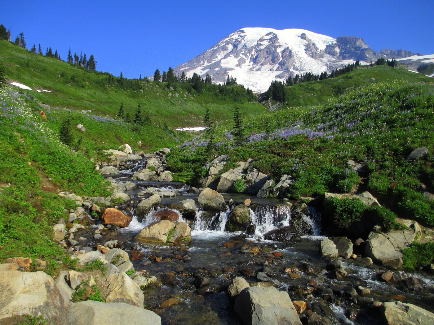
Paradise wildflower meadows in late July and August
Paradise sits at 5,400 feet on Rainier's south flank, and for six weeks in late summer the meadows around the visitor center are one of the great wildflower shows in North America. Short paved paths loop from the parking lot through the bloom — good for anyone — and the view of the mountain dominates every frame. Go on a weekday, arrive before 10 a.m. because Paradise parking fills by late morning in peak season, and stay on the trails to avoid trampling plants that have a six-week window to reproduce.
Skyline Trail loop from Paradise with glacier views
The classic Paradise day hike — a 5.5-mile loop that climbs 1,700 feet to Panorama Point at 6,800 feet. You traverse wildflower meadows, climb switchbacks across snow patches that linger into August, and get a head-on view of the Nisqually Glacier grinding down the mountain's south side. Marmots whistle from every other rock. Start by 8 a.m., bring layers — the temperature drops 20 degrees and the wind picks up as you climb — and wear real hiking boots. Allow four to five hours.
Sunrise visitor area for the most dramatic Rainier views
Sunrise, on the northeast side of the mountain at 6,400 feet, is the highest place you can drive in the park and arguably the single best spot to stare at Rainier. The road is usually open only from early July through September. Short trails like Sourdough Ridge give you subalpine meadows and the mountain filling the sky to the southwest. It's sunnier and drier than Paradise — the rain shadow side — and worth the drive even if you've already done Paradise.
Wonderland Trail — a 93-mile circumnavigation of the mountain
The ambitious hiker's bucket list — a 93-mile trail that circles Rainier entirely, climbing and descending over 22,000 feet of elevation across glacier rivers, old-growth forest, and high alpine passes. Most thru-hikers take 10 to 14 days; permits are competitive and go through a lottery in March. If you're not up for the full loop, you can day-hike iconic sections like Summerland or Spray Park from trailheads around the park. Even seasoned backpackers rate this as a career hike.
Myrtle Falls viewpoint framing Rainier above the cascade
A half-mile round-trip from the Paradise visitor center to a viewpoint of a 60-foot cascade with the mountain rising directly behind it. Probably the most photographed composition in the park, and a legitimately great one. The paved path is flat enough for strollers or wheelchairs, and the view is only a 10-minute walk from the parking lot. Hit it in early morning for side light on the mountain, or late afternoon for the falls in shadow and the summit still lit.
Grove of the Patriarchs — ancient trees on an island in the Ohanapecosh River
A 1.5-mile loop on the park's quieter southeast corner that crosses a suspension bridge onto a river island full of thousand-year-old western red cedars and Douglas firs, some 25 feet in circumference. The trail is flat and shaded — a great midday break on a hot August day — and the suspension bridge sways enough to be memorable. Closures happen occasionally when the bridge or trail floods; check the visitor center before driving out.
Emmons Glacier overlook from Sunrise
From the Sunrise area, a 3-mile round-trip hike out to a ridge overlooking the Emmons Glacier — the largest glacier by surface area in the contiguous US, a mile and a half wide and full of ice-blue crevasses. The trail is mostly above tree line with the mountain in your face the whole way. Bring binoculars to spot mountaineers roped up on the glacier surface in June and July, working the standard summit route on the east side.
Getting There & When to Go
Seattle-Tacoma International Airport is about two hours northwest of the Nisqually entrance — the park's main year-round gateway on the southwest side. The White River entrance to Sunrise is 2.5 hours from Seattle and only open roughly July through September. Come in late July through August for snow-free trails, running waterfalls, and the peak of the wildflower bloom at Paradise — the shortest and most rewarding window of the year. September quiets down with the first fall color and cooler nights. Timed entry reservations are required for some areas during summer; check the park website. Winter closes Sunrise and Stevens Canyon but keeps Paradise open for snowshoeing and tubing from a small concessionaire.
Where to Stay
Paradise Inn is the classic in-park lodge — built in 1916 with Alaska cedar timbers and a massive stone fireplace, open May through early October, and booking out months ahead for the summer. National Park Inn in Longmire is smaller, open year-round, and a good winter base. Both are run by Rainier Guest Services. Outside the park, Ashford is the main gateway village just outside the Nisqually entrance with cabin rentals and a few small inns — the best choice if the in-park lodges are booked. Packwood sits near the southeast entrance, and Enumclaw is the gateway for Sunrise on the northeast side. Campgrounds at Cougar Rock and Ohanapecosh take reservations on recreation.gov.
Frequently Asked Questions
- Do I need a timed entry reservation?
- For parts of summer, yes. The Paradise corridor and the Sunrise corridor have both used timed entry reservations in recent summers, typically from late May through early September during peak daytime hours. Rules change year to year — check nps.gov/mora before your trip and book on recreation.gov.
- Can I climb to the summit?
- Yes, but only with serious mountaineering skills, proper gear, and a climbing permit. Most climbers hire a guide service like RMI or IMG for a three-day ascent via Camp Muir. Do not attempt the summit without crevasse rescue and self-arrest skills — Rainier kills experienced climbers most years.
- When is Sunrise open?
- The road to Sunrise typically opens in early July once the snowpack melts and closes in late September or early October. Paradise, by contrast, is open year-round though the road can close briefly during big snowstorms. Always check the park's road status page before you drive up.
- Will I actually see the mountain?
- Maybe. Rainier makes its own weather and is frequently socked in by its own clouds even on days Seattle is sunny. Your odds go up in late July and August, and early morning is generally clearer than afternoon. Locals call a visible day 'the mountain is out.' Plan multiple days if seeing it matters to you.
Plan Your Visit
Book Nearby HotelsHave you visited Mount Rainier?
Track all 63 national parks on your map