National Park · TX · Est. 1966
Guadalupe Mountains
Overview
Guadalupe Mountains is the southernmost Rocky Mountain outpost and the least-visited major park in Texas — which is a tell. There's no lodge, no scenic drive, barely any cell service, and the wind can be ferocious. What there is: the highest point in Texas, the fossilized remains of a 265-million-year-old Permian reef, and an uncrowded wilderness a few hours from El Paso that rewards hikers willing to earn their views. The park's signature feature is Guadalupe Peak itself, an 8,751-foot summit that sits at the exposed core of the ancient Capitan Reef — a seafloor formation from a time when West Texas was tropical ocean. Today the reef is desert country, but the elevation creates surprising pockets of relict Douglas fir and ponderosa pine in The Bowl, and a narrow slot in McKittrick Canyon where bigtooth maples turn gold and red in late October for what is, legitimately, the best fall color in Texas. Distances here are deceptive — the state-line ruler of West Texas highway miles, plus the sheer absence of services, means you need to arrive prepared. Fill up in Van Horn or Carlsbad, bring more water than you think, and don't underestimate the wind on the summit trail.
What to See & Do
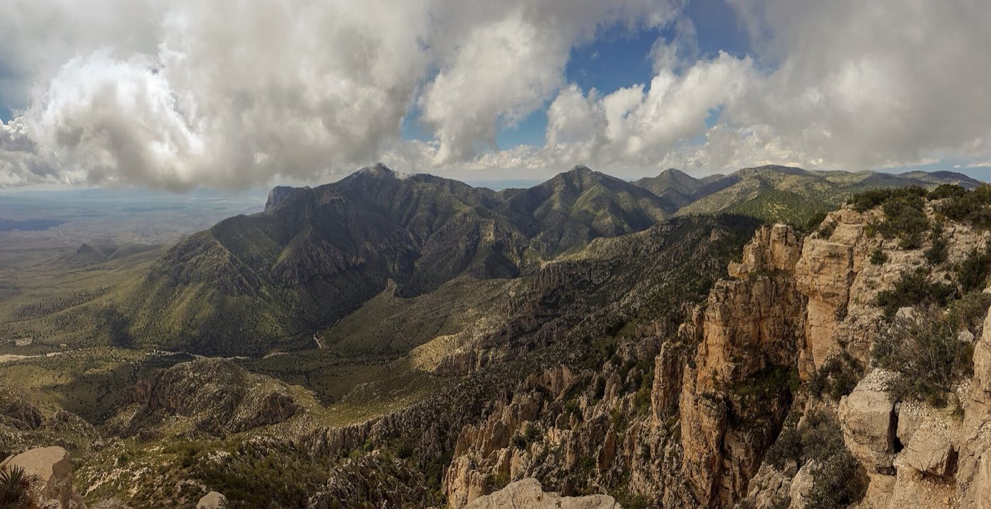
Guadalupe Peak summit trail
The 8.4-mile roundtrip to the Texas highpoint climbs 3,000 feet with no shade, exposed ridgelines, and the kind of wind that will take your hat off the mountain. Start at dawn — the Pine Springs Trailhead parking lot fills by 8 a.m. on cool-weather weekends. The final mile runs along a knife ridge with big drops on both sides. At the summit, a stainless-steel pyramid and a metal ammo box of logbooks mark the highest point in Texas. Carry three liters of water per person; there's none on the trail. Eight hours is a reasonable pace.
McKittrick Canyon fall colors among bigtooth maples
McKittrick Canyon is a springs-fed desert oasis on the park's east side, and from roughly October 20 through early November the bigtooth maples and walnut trees turn gold, orange, and crimson — the best fall color in Texas. The 4.8-mile roundtrip to Pratt Cabin is mostly flat and suitable for families; the 6.8-mile roundtrip to the Grotto adds a shaded lunch spot and waterfall. The canyon gate is open 8 a.m. to 6 p.m. only; plan accordingly.
The Bowl trail
The Bowl is an 11-mile loop that climbs Tejas and Bush Mountain trails into a high-elevation basin of ponderosa pine, Douglas fir, and southwestern white pine — a relict forest left behind as the climate warmed since the last ice age. It's one of the park's most rewarding full-day hikes and one of the least crowded. The loop gains 2,500 feet of elevation. Bring a map; trail signs are minimal and the junctions aren't always obvious. Expect eight to nine hours.
El Capitan's dramatic cliff face at sunset
El Capitan — not the Yosemite one — is the 8,085-foot limestone prow that forms the park's southern tip, visible for miles along U.S. 62/180. The sunset view from the pullout on the highway a few miles southwest of the Pine Springs entrance lights the cliff face pink and orange against the Chihuahuan Desert. No hike required; bring a camera and a thermos.
Smith Spring oasis trail
The 2.3-mile roundtrip loop from Frijole Ranch Museum leads through desert grassland to Smith Spring, a small but genuine oasis where permanent water draws cottonwoods, maples, and an improbable concentration of wildlife. Mule deer, gray fox, and songbirds gather at the water; elk tracks are common. This is an achievable hike when the summit feels like too much, and a good late-afternoon option. The museum at the trailhead is worth a quick stop.
Williams Ranch historic homestead
Williams Ranch is a preserved 1908 homestead tucked at the base of a steep escarpment, reached only by a 7.5-mile one-way dirt road that requires a high-clearance 4x4 and a gate key checked out from the visitor center. You get the key, drive out, tour the ranch and cabin, and return the key on the way out — no sharing with other visitors. This is the park's most adventurous side trip and rewards people willing to drive slowly and carefully over rough terrain.
Devil's Hall slot canyon on the Pine Springs trail
Devil's Hall is a 4.2-mile roundtrip route that starts on the Tejas Trail and then follows a rocky wash up to a narrow limestone slot — a 100-foot-long, 15-foot-wide natural hallway carved through the reef rock. The wash section requires rock-hopping and some mild scrambling, and flash floods are a real hazard when thunderstorms build over the high country. Skip it if rain is in the forecast. The hall itself is a dramatic payoff for a moderate day hike.
Getting There & When to Go
El Paso International Airport is the closest major airport, about two hours west on U.S. 62/180. Carlsbad, New Mexico, is 45 minutes north and is the natural pairing with Carlsbad Caverns National Park, which shares the same mountain range. Midland-Odessa is another option from the east, about three hours away. The park is open year-round with no entrance station or reservation system — an honor-system pay station at the Pine Springs Visitor Center takes the $10 per-person fee. October through November is the prime window: fall color in McKittrick Canyon, comfortable hiking temperatures, thinner crowds. Spring brings desert wildflowers and relentless wind. Summer is hot.
Where to Stay
There's no lodging inside the park. The closest hotels are in Whites City (35 miles north, basic), Carlsbad, New Mexico (45 miles, full range of chains), and Van Horn, Texas (55 miles south, small but functional). Most visitors combine this park with Carlsbad Caverns and base in Carlsbad. The park has two campgrounds — Pine Springs (RV and tent, first-come-first-served) and Dog Canyon (tent only, remote and quiet) — plus 10 backcountry sites that require a permit. The high desert wind at Pine Springs can shake a tent violently; stake it well or consider RV camping instead.
Frequently Asked Questions
- Is Guadalupe Peak a difficult hike?
- Yes — it's 8.4 miles roundtrip with 3,000 feet of elevation gain, exposed to sun and wind the entire way, and there's no water on the trail. Most fit hikers take six to eight hours. Start at dawn, carry three liters of water, and turn around if storms build; the summit ridge is dangerous in wind or lightning.
- When does McKittrick Canyon peak for fall color?
- Usually the last week of October through the first week of November, though timing shifts year to year with temperature and rainfall. The park posts weekly color reports starting in mid-October. Visit on a weekday if possible — peak weekends fill the small McKittrick parking lot by mid-morning, and the gate closes for the night at 6 p.m.
- Can I combine Guadalupe Mountains with Carlsbad Caverns?
- Yes, and most people do. They're 45 minutes apart on the same mountain range, with Carlsbad just over the New Mexico line. A typical trip stays in Carlsbad two or three nights, doing caves one day and Guadalupe Peak or McKittrick another. Both parks are small enough to see the highlights across a long weekend.
- Is there cell service in the park?
- Barely — expect no reliable service at the trailheads, campgrounds, or on most of the trails. A faint signal sometimes reaches the upper sections of Guadalupe Peak. Download offline maps before you arrive, tell someone your plan, and don't count on calling out if something goes wrong. Rangers recommend self-reliance.
Plan Your Visit
Book Nearby HotelsHave you visited Guadalupe Mountains?
Track all 63 national parks on your map