National Park · AK · Est. 1980
Wrangell-St. Elias
Overview
Wrangell-St. Elias is the largest national park in the United States — 13.2 million acres, bigger than Switzerland, roughly the combined size of Yellowstone, Yosemite, and Switzerland again for good measure. It holds four mountain ranges, some of the largest non-polar glaciers on Earth, active volcanoes, and a frontier mining town that's still inhabited by fewer than 100 year-round residents. You will not casually see this park on a weekend. Two gravel roads lead inside its boundaries — the McCarthy Road and the Nabesna Road — and most of the interior is accessible only by bush plane, raft, or a serious multi-day hike. That's the point. What you get in exchange for the drive or the flight is a wilderness without guardrails: a glacier you can walk onto without anyone herding you, a 1900s copper mine that still has its mill buildings standing in red-painted Alaskan weather, peaks over 16,000 feet visible from the gravel runway. Plan to give it at least three full days, rent a vehicle you don't mind putting gravel miles on, and treat flightseeing as non-optional if you really want to understand the scale of where you are.
What to See & Do
Kennecott copper mine ghost town and mill building
At the end of the McCarthy Road, the Kennecott Mill is an abandoned company town that produced some of the richest copper ore in history between 1911 and 1938, then shut down overnight when prices collapsed. The 14-story red mill building is the photograph you've seen of Alaska — and it's still standing. The NPS and a private concessioner run daily guided tours of the mill's interior in summer, where you walk down through the ore-crushing levels the way the rock did. Reserve the tour ahead; you can't just walk in. The surrounding town of bunkhouses, the general store, and the hospital are open to self-guided exploration.
Root Glacier hike and ice climbing on the glacier surface
From Kennecott, a well-trodden footpath leads about two miles to the edge of the Root Glacier, where you can strap on crampons (rent them from guide outfits in town) and walk onto active glacier ice. Blue meltwater pools, deep moulins, and seracs the size of cars are all within an easy half-day. Guided ice climbing trips go deeper — you'll rope up at the edge of a moulin and climb vertical ice with a guide belaying from above. Footing is serious; this is not a hike for running shoes, and unguided glacier travel past the standard crampon loop requires real mountaineering experience.
McCarthy — a quirky frontier town accessible only by footbridge
The town of McCarthy sits at the end of the 60-mile McCarthy Road, but cars stop at the Kennicott River — you leave the vehicle, walk across a narrow pedestrian footbridge over the gray glacial water, and catch a shuttle van the last half mile into town. The walk-in feels like crossing into another country. McCarthy has a couple of restaurants, one saloon with live music most summer nights, a small lodge, and permanent residents who mostly run guiding or lodging businesses through the short summer season. It's the staging ground for everything else you'll do in the park.
Flightseeing over the Wrangell and St. Elias mountain ranges
Nothing on the ground conveys the scale of this park the way a small-plane flight does. Operators out of McCarthy, Chitina, and Glennallen run 60-to-120-minute flightseeing tours that lift you over the Bagley Icefield, the volcanic summits of Mount Wrangell and Mount Drum, and rivers of ice 100 miles long. Weather calls the shots — low clouds cancel flights routinely, so build a buffer day into your itinerary if you want to guarantee flying. Morning light gives you the cleanest air; evening gives you alpenglow.
Nabesna Road — one of two roads into the park
The park's quieter access is the 42-mile Nabesna Road off the Glenn Highway in the northern part of the park. It's gravel, shared with moose, and dead-ends at the abandoned Nabesna gold mine. Unlike the McCarthy side, there's almost no infrastructure — a handful of homesteads, dispersed camping, and trailheads into subalpine tundra where you can hike for days without seeing another person. The road is passable in a standard SUV most of the summer, but several stream crossings near the end require clearance; ask at the Slana Ranger Station about current conditions before you commit past mile 30.
Copper River salmon fishing
The Copper River drains much of the park's ice and empties into the Gulf of Alaska, and its salmon runs are among the most prized in the world — king and sockeye salmon swim hundreds of miles upstream to spawn. Dip-net and rod-and-reel fishing are available to non-residents with the right permits and licenses; several lodges and guide services out of Chitina and Glennallen handle the logistics. King season typically runs mid-June through mid-July, sockeye mid-July through August. The river is fast, cold, and silty — guided is the right call for first-timers.
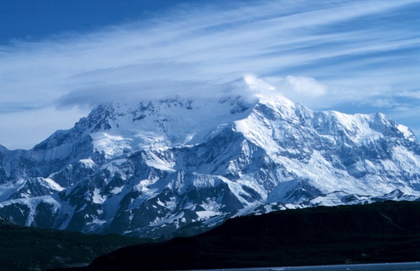
Mount Blackburn and Mount Sanford volcano views
The Wrangell volcanoes line up along the horizon from almost anywhere on the park's road system. Mount Blackburn, 16,390 feet, and Mount Sanford, 16,237 feet, are the highest and the most photographed — snow-plastered year-round and visible on clear days from the Richardson Highway even before you turn off toward the park. The pullout at Willow Lake on the Richardson Highway, about 30 miles outside the park boundary, is the classic roadside photograph: the full range reflected in still water at sunrise.
Getting There & When to Go
Most visitors fly into Anchorage and drive east — it's roughly seven hours to Chitina, where the pavement ends and the McCarthy Road begins, or five hours to Slana for the Nabesna Road. A rental 4x4 is worth the upgrade; the McCarthy Road is gravel with sharp railroad-era spikes still occasionally surfacing, and tire punctures are routine. The accessible season is basically June through mid-September, with July and August offering the warmest weather, the longest days (close to 20 hours of light in June), and open glacier guiding. By late September the roads ice over and most lodges close. Weather shifts fast — rain gear, layers, and a flexible itinerary are not optional.
Where to Stay
Inside the park, the Kennicott Glacier Lodge and Ma Johnson's Hotel in McCarthy are the two established options, both historic, both limited in rooms, and both book out months ahead for peak summer. A handful of cabins and hostels in McCarthy fill the budget end. Camping is widely available — dispersed, free, and up to you — along both road corridors. Outside the park, Glennallen makes a practical base for the Nabesna side with chain motels and a grocery store, and Chitina at the head of the McCarthy Road offers a few cabins and a general store before the gravel starts. Fuel up and stock food before you turn off the pavement; neither McCarthy nor Nabesna has a full grocery.
Frequently Asked Questions
- Can I drive all the way to McCarthy or do I have to fly?
- You can drive — but the last 60 miles from Chitina is gravel road, and the road dead-ends at the Kennicott River. You park on the east side, walk across a pedestrian footbridge into McCarthy, and catch a shuttle van to Kennecott. Flying in from Chitina or Glennallen is a faster alternative in a small plane.
- Is a 4x4 required for the McCarthy Road?
- Not strictly required, but strongly recommended. Most rental companies in Anchorage prohibit taking their standard vehicles on the McCarthy Road because of tire damage from old railroad spikes. Rent a specialty SUV from a company that allows gravel roads, and carry a full-size spare.
- How long should I plan to spend in the park?
- Three to five days is the sweet spot. One full day to drive in, two days for Kennecott, glacier hiking, and a flightseeing trip, and a buffer day for weather. Less than three days and you won't make the long gravel drive feel worthwhile; more than five and you're committing to backcountry or multi-day river trips.
- Are there bears in the park?
- Yes — both black bears and grizzly bears range throughout the park. Sightings on the road corridors are common, especially near salmon streams in July and August. Carry bear spray on every hike, store food properly at campsites, and make noise on overgrown trails. Guides are a good idea if you're new to bear country.
Plan Your Visit
Book Nearby HotelsHave you visited Wrangell-St. Elias?
Track all 63 national parks on your map