National Park · AK · Est. 1980
Glacier Bay
Overview
Glacier Bay doesn't really exist on a road system. Most visitors see it from the deck of a cruise ship threading up the bay toward the Margerie and Grand Pacific glaciers, where a ranger boards in the morning and narrates through a loudspeaker as half-ton blocks of ice shear off the tidewater face and slap into the sea. If you're traveling independently, you fly into Gustavus on a small plane, check into the Glacier Bay Lodge at Bartlett Cove, and book a day-boat tour up the bay the next morning. The park's core fact is speed. In 1794, when Captain Vancouver mapped this coast, Glacier Bay didn't exist — it was a single ice sheet 4,000 feet thick. By the time John Muir arrived in 1879, the ice had retreated 40 miles. Today it has retreated 65 miles, and the forests, meadows, and salmon runs are reorganizing themselves on the newly uncovered ground in real time. It is the best living demonstration of ecological succession on Earth. Humpback whales feed here all summer, tufted puffins nest on the outer islands, and the Huna Tlingit — whose ancestors fled the advancing ice in the 1700s — have their tribal house back on park land at Bartlett Cove. The park is also close to 90% water, which means a boat or kayak is the baseline for seeing anything beyond the headquarters area.
What to See & Do
Margerie Glacier calving icebergs into Tarr Inlet
At the head of the bay's west arm, the mile-wide face of Margerie Glacier rises 250 feet above the water and drops another 100 feet below the surface. Boats idle a quarter mile out while you watch and listen — a deep crack, a white line running down the ice, and then a tower of ice shearing off with a sound the NPS calls 'white thunder.' You'll hear it first, then see it, a full second of travel delay at that distance. Every concession day-boat from Bartlett Cove stops here; most cruise ships spend an hour at the face.
Humpback whale bubble-net feeding
Glacier Bay is one of the only places in the world where humpbacks reliably use cooperative bubble-net feeding — one whale dives, circles a school of herring while exhaling a ring of bubbles, and the pod rockets up through the trapped fish with mouths wide open. From July through early September, day boats detour to watch if a group is feeding. Bring a zoom lens and a warm jacket; the deck wind is cold even in August.
Sea kayaking among icebergs in Muir Inlet
Independent sea kayakers get dropped off by the day-boat at points along Muir Inlet on the east side of the bay and paddle among icebergs, sea otters, and seals hauled out on growlers. Rent touring kayaks and drybags from Glacier Bay Sea Kayaks at Bartlett Cove; permits are required for overnight camping and involve a required orientation. Skills matter here — cold water, big tides, and sudden weather. For a first paddle, day trips out of Bartlett Cove into Bartlett Cove itself are the low-commitment option.
Bartlett Cove rainforest trail and lodge
A one-mile forest loop at park headquarters through 250-year-old Sitka spruce and western hemlock, passable in sneakers and worth slow walking for the moss-layered understory and the skeleton of a humpback whale — 'Snow' — mounted alongside the visitor center. The Glacier Bay Lodge here is the only park lodge, and even if you're day-tripping, the lodge porch on Bartlett Cove is a good place to wait for a boat, eat a salmon plate, or watch sea otters rolling in the kelp just offshore.
Tlingit cultural heritage at the Huna Tribal House
Xunaa Shuká Hít — the Huna ancestors' house — opened at Bartlett Cove in 2016, the first permanent Tlingit clan house built on Glacier Bay land in over 250 years. The building carries Hoonah clan crests carved by Tlingit artists and hosts cultural programs led by Huna tribal members. Attend one if your schedule lines up (summer weekly schedule posted at the visitor center); it reframes the park as a homeland that was covered by ice, then uncovered, rather than an 'empty' wilderness.
Brown bear and mountain goat viewing from tour boats
The concessionaire day-boat runs a nine-hour up-bay loop from Bartlett Cove and stops repeatedly for brown bears fishing on beaches, mountain goats on the Gloomy Knob cliffs, and Steller sea lions hauled out on South Marble Island. Binoculars are mandatory — the boat stays well offshore. Onboard rangers narrate throughout, and the boat has heated indoor viewing and an outdoor top deck for when the sun is out. Book weeks ahead in July and August.
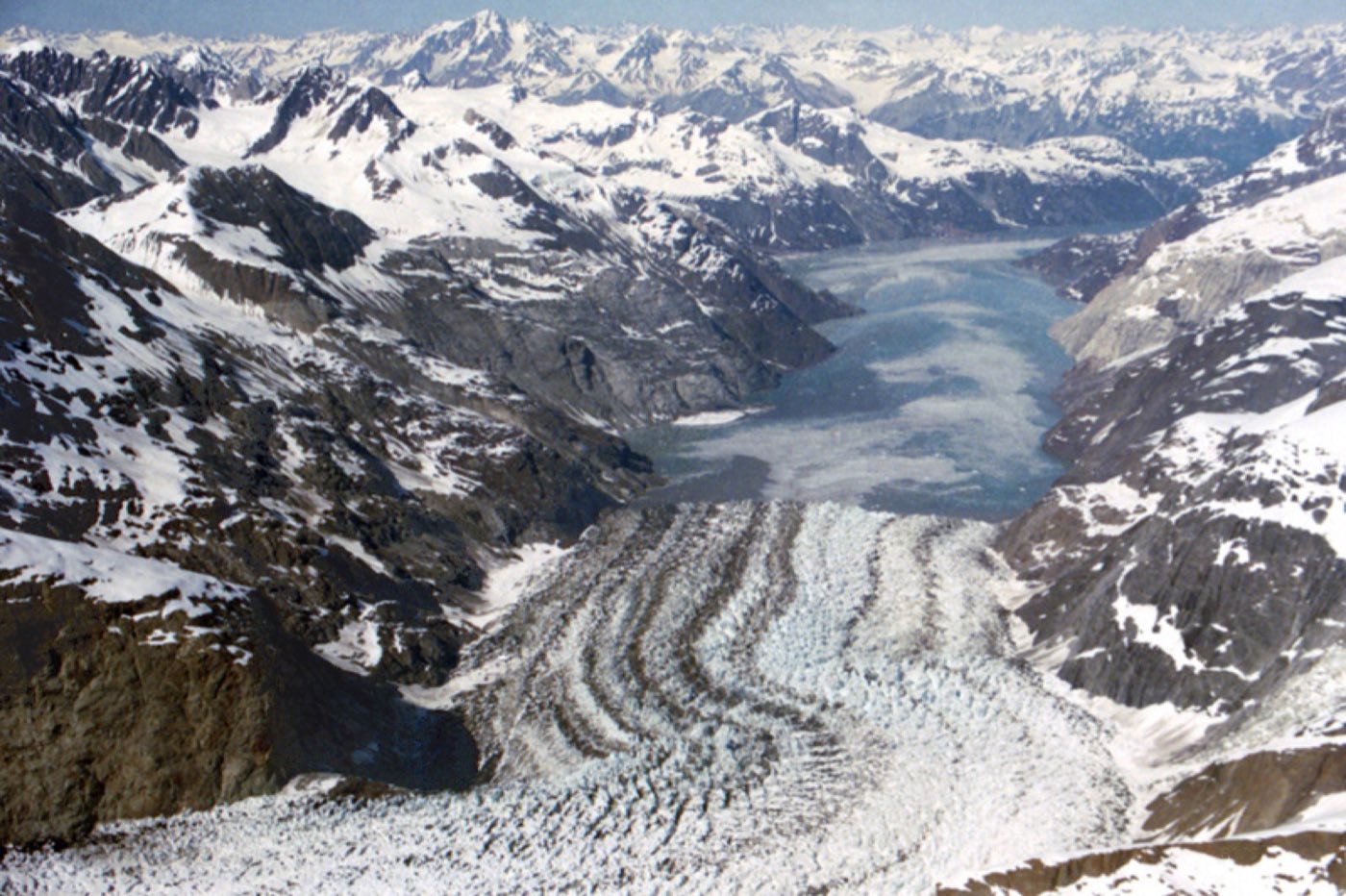
Ecological succession walk from bare rock to old-growth forest
Because the bay's ice retreated from the mouth (out in Icy Strait) all the way to the heads of Tarr and Muir inlets over the last 250 years, the vegetation at the head of the bay is almost zero, the middle bay is alder and young spruce, and Bartlett Cove near the mouth is mature temperate rainforest. Ranger-led walks at Bartlett Cove explain it in place, and you can see the whole sequence yourself in a single up-bay day-boat trip. There is no other place on Earth where the textbook diagram exists at the scale of an afternoon's boat ride.
Getting There & When to Go
Unless you're on a cruise ship (the vast majority of Glacier Bay visitors are), the only way in is to fly from Juneau to Gustavus on Alaska Airlines or on a small-plane charter — about 30 minutes. From Gustavus, it's a 10-mile taxi or shuttle ride to Bartlett Cove, the park headquarters and only developed area. Ferry service from Juneau runs seasonally but is infrequent. The season is late May through mid-September. June and July have the longest days and best whale watching; cruise ships run throughout summer. Weather is coastal Alaska — cool, often cloudy, often rainy, 50s to 60s°F at the warmest. Pack rain shell, fleece, and layers.
Where to Stay
Glacier Bay Lodge at Bartlett Cove is the only lodging inside the park — 56 simple rooms in a 1960s cedar building with a restaurant and a deck over Bartlett Cove. It's the base for day-boat tours and kayak put-ins and books out early in peak months. Gustavus, 10 miles down the road, has a handful of small inns and B&Bs — Gustavus Inn and Annie Mae Lodge are the standouts, both with home-style meals and airport pickups built into the rate. Bartlett Cove Campground is free but requires a ranger orientation and bear canisters for all food. Most cruise passengers see the park only from the ship and don't overnight on shore.
Frequently Asked Questions
- Can I visit Glacier Bay without a cruise?
- Yes. Fly from Juneau to Gustavus (about 30 minutes on Alaska Airlines), stay at Glacier Bay Lodge or in Gustavus, and book the full-day concessionaire boat tour up the bay from Bartlett Cove. Independent visits give you more time on the ground, access to kayaking, and the Huna Tribal House programs.
- Do cruise ships actually enter the park?
- Yes — the park permits two large cruise ships per day in summer, and a park ranger boards each one to narrate the visit. Ships spend roughly eight hours inside, typically pausing at Margerie Glacier for an hour or more before turning around. It is one of the most-visited backcountry parks in the NPS precisely because of these ship days.
- How likely am I to see whales?
- Very likely between July and September. Humpbacks feed in the lower bay all summer, and the day-boat tour almost always produces sightings — often within the first hour out of Bartlett Cove. Orcas are less common but show up in small groups throughout the season. Bring binoculars and dress warmer than you think you need.
- How much does an independent Glacier Bay trip cost?
- Budget roughly $400 to $700 per person per day for an independent visit once you're in Alaska: flights from Juneau to Gustavus run $150 to $250 round-trip, lodge rooms $200 to $350 a night, and the up-bay day-boat about $250 per person. Kayak rentals and guided trips add more. Compared with cruise ship equivalents, you get far more time and flexibility for similar daily spend.
Plan Your Visit
Book Nearby HotelsHave you visited Glacier Bay?
Track all 63 national parks on your map